宋瑞玲 , 吴恺悦
, 吴恺悦
Ruiling Song, Kaiyue Wu
通讯作者:
收稿日期: 2018-01-9
接受日期: 2018-03-19
网络出版日期: 2018-03-20
版权声明: 2018 《生物多样性》编辑部 版权所有.《生物多样性》编辑部
展开
摘要
全球物种多样性的持续下降使得生物多样性保护面临巨大挑战, 海洋生物多样性的保护任务尤其艰巨。海洋保护区是保护生物多样性的有效方式之一, 如何对其成效进行评估是当前研究热点。然而, 目前针对海洋保护区的评估体系较少, 而且评估指标多侧重于管理成效。近年来随着全球生物多样性监测网络和数据库的建立, 以及多种新技术(如遥感、声呐系统、卫星追踪、基因组学等)在海洋生物多样性监测中的应用, 使得从生态系统到基因水平的多层次连续监测成为可能。基于此, 建议未来我国海洋保护区成效评估应在充分利用新技术方法的基础上, 加强长期科学监测, 建立并完善生物多样性监测数据库和信息共享机制, 发展跨学科的综合保护成效评估体系, 加强基于生物多样性监测的保护成效评估。
关键词:
Abstract
The continued decline of global biodiversity presents a huge challenge for biodiversity conservation, especially for marine biodiversity conservation. As an effective way to protect biodiversity, evaluating the effectiveness of MPAs (Marine Protected Areas) is becoming a critical issue. However, only limited assessment methodologies were specially designed for MPAs so far. Moreover, evaluation indicators have mainly focused on management effectiveness. Recently, the establishment of global biodiversity monitoring networks and databases and the application of new technologies (including remote sensing, sonar system, satellite tracking, and genomics) have provided available data and information for quantified conservation effectiveness evaluations at multiple levels from ecosystems to genes. Future evaluation should be based on long-term scientific monitoring with the assistance of new technologies, promoting the establishment of the biodiversity monitoring database and information sharing, and developing integrated and interdisciplinary evaluation systems to evaluate conservation effectiveness.
Keywords:
海洋作为地球上最大的生态系统, 具有极其丰富的生物多样性, 海洋物种约占全球生物物种总数的80% (Halpern, 2014)。随着人口快速增长, 海洋开发力度加大, 海洋生物多样性受到越来越大的威胁, 其保护迫在眉睫。海洋保护区(Marine Protected Areas, MPA)是保护典型海洋生态系统和生物多样性、拯救珍稀濒危物种的重要方式(Hockings et al, 2006)。虽然全球海洋保护区的数量和面积持续增长, 但仍一定程度存在重数量规模、轻质量效益的问题。大多数现有海洋保护区因规划不完善或管理技术缺乏, 监测管控力量弱等原因, 导致保护区形同虚设(Halpern, 2014)。针对此现状, 许多国家、地区和机构陆续开展了保护区成效评估的研究和实践。
保护区成效评估主要包括管理成效评估和保护成效评估。管理成效评估即评估保护区在多大程度上实现了预期的管理目标, 主要评价保护区设计与规划结果、管理体制及过程的充分性与合理性、保护区目标的达成度(Hockings et al, 2006)。保护成效评估即评价保护区对其主要保护对象的保护效果及其在维持生物多样性和保障生态系统服务功能等方面的综合成效(王伟等, 2016)。通过海洋保护区成效评估, 可以帮助管理者明确保护现状, 识别保护空缺和存在的问题, 从而提高保护行动的有效性。
我国的海洋保护起步相对较晚, 海洋生物多样性保护与经济发展矛盾突出(曾江宁等, 2016; 王伟等, 2016), 未来既需要建立更多新的海洋保护区, 也亟需评估现有海洋保护区的保护成效。在海洋保护区数量和面积持续增加的背景下, 本文将总结目前评估海洋保护区管理成效和保护成效的研究进展, 以期为我国海洋保护区成效评估提供参考。
自20世纪60年代以来, 随着全球对生物多样性保护的重视, 海洋生物多样性保护得以加强(曾江宁, 2013) , 但早期发展缓慢。1962年IUCN提出“海洋自然保护区”的概念之后, 各国陆续建立了海洋保护区。截至1970年, 27个国家建立了118个海洋保护区(Björklund, 1974), 1994年增至1,306个(Kelleher, 1996), 2003年全球海洋保护区总数达3,858个(UNEP, 2003)。2010年联合国《生物多样性公约》第10次缔约方大会提出“至2020年底将海域面积的10%列为保护区域”。这推动了海洋生物多样性保护的快速发展, 海洋保护区的数量和面积持续增加(Thomas et al, 2014)。截止到2017年9月, 全球海洋保护区覆盖了2,300万km2 (约6.35%)的海洋面积。近年来, 随着超大保护区的建设, 预计2025年有望达成覆盖10%海洋面积的目标(Lisa & Danile, 2016)。
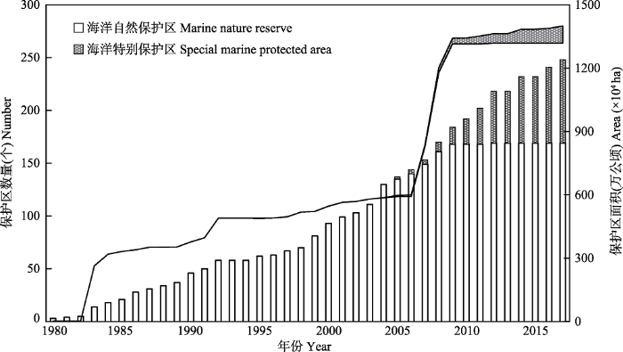
狭义上我国的海洋保护区体系分为两大类型, 即海洋自然保护区和海洋特别保护区, 其中, 海洋特别保护区又包括海洋公园(曾江宁等, 2016)。自1963年我国建立第一个海洋保护区蛇岛老铁山自然保护区后, 海洋保护区的发展停滞了近20年(叶有华等, 2008), 直至20世纪80年代海洋保护区的面积和数量又开始逐步增加(图1)。在2005年开始建立海洋特别保护区, 2011年开始建立海洋公园。自1980年以来, 平均每年新增约7个海洋保护区, 覆盖的海洋总面积约14万km2, 约占我国海域面积的4.6% (曾江宁等, 2016)。
图1 自1980年以来中国海洋保护区的数量和面积持续增长(1980-2011年的数据来自曾江宁(2013), 2012-2017年的数据来自国家海洋局网站)
Fig. 1 The number and area of marine protected areas in China have been growing since 1980. Data from 1980 to 2011 refer to
综上所述, 经过半个多世纪的发展, 全球(包括我国)海洋保护区的数量和面积在持续增长, 但与生物多样性快速降低的现状相比(Halpern, 2014)仍显不足。如何提高海洋保护区的管理质量和保护成效, 有效发挥其在生物多样性保护中的作用, 是海洋保护区研究中的重要问题(Wu et al, 2017)。
相比于陆地生物多样性的保护, 海洋保护区成效评估的研究和实践不足, 发展滞后(IUCN, 2012; 洪晓巧和方秦华, 2016)。最初用于保护区管理成效评估的方法大多是针对陆地生物多样性保护的体系, 其中应用范围最广的是IUCN世界保护区委员会(World Commission on Protected Areas, WCPA)提出的保护区管理框架, 以及由此衍生出的评估体系如自然保护区管理快速评估和优先性确定方法(Rapid Assessment and Prioritization of Protected Area Management, RAPPAM) (Ervin, 2003)、“保护区管理成效跟踪工具”(Management Effectiveness Tracking Tool, METT) (Stolton et al, 2003)等。
早期海洋保护区管理成效评估也多沿用这些陆地保护区评估体系。直至2004年世界银行和世界自然基金会(WWF)在WCPA框架和METT的基础上, 发布了“海洋保护区打分卡”体系(World Bank, 2004), 针对海洋保护区调整了部分评估指标, 但大体仍与METT类似, 并未充分考虑海洋的特殊属性如开放性、流通性等。与此同时, IUCN编写了《海洋保护区管理成效评估指南》, 增加了针对海洋特殊属性的内容, 是目前全球最权威和最全面的海洋保护区管理成效评估体系(Pomeroy et al, 2005)。
此外, 一些研究机构也针对其评估的海洋保护区特点, 综合了多种评估框架, 建立了新的评估体系。如中美洲大堡礁项目(Mesoamerican Barrier Reef Systems, MBRS)针对中美洲4个国家的珊瑚礁系统制定了《中美洲海洋保护区管理成效快速评估手册》(MBRS, 2004), 该体系在WCPA框架的基础上, 增加了有针对性的指标如珊瑚礁和红树林盖度、海草密度等。
表1列出了4种海洋保护区成效评估体系的特征和应用情况对比。
表1 主要海洋保护区管理成效评估体系比较
Table 1 Comparison of main methodologies for assessing management effectiveness of marine protected area
| METT Management Effectiveness Tracking Tool | 海洋保护区打分卡 Marine Tracking Tool | 海洋保护区管理成效评估指南 How is your MPA doing | 中美洲海洋保护区管理成效快速评估手册 Manual for the Rapid Evaluation of Management Effectiveness in Marine Protected Areas of Mesoamerica | |
|---|---|---|---|---|
| 开发机构 Developer | WWF/世界银行 WWF/World Bank | WWF/世界银行 WWF/World Bank | IUCN/WWF/NOAA | 中美洲大堡礁系统 Mesoamerican Barrier Reef System |
| 评估人员 Objects | 保护区管理者、工作人员Managers and staff | 保护区管理者、工作人员、专家 Managers, staff and experts | 保护区管理者 、工作人员、专家、相关官员、社区居民 Managers, staff, experts, relevant officials, and local communities | |
| 人员专业要求 Professional requirements | 低 Low | 低 Low | 高 High | 高 High |
| 人力成本 Human cost | 低 Low | 低 Low | 高 High | 较低 Lower |
| 可重复性 Repeatability | 好 Good | 好 Good | 不好 Bad | 较好 Better |
| 主观影响 Effect of subjectivity | 较小 Smaller | 较大 Larger | 较小 Smaller | 较小 Smaller |
| 针对性 Marine-relevant | 无 None | 弱 Weak | 强 Strong | 强 Strong |
| 实践应用 Application | 至少用于86个国家的1,150个保护区 Applied in 1,150 protected areas across over 86 countries | 欧洲广泛应用 Widely applied in protected areas of Europe | 至少用于200多个保护区 Applied in over 200 protected areas | 中美洲大堡礁系统 Applied in Mesoamerican Barrier Reef System |
| 应用建议 Suggestion | 可多次重复评估并监测变化 Best for repeat evaluation and monitoring | 指标综合全面 Reference for integrated indicators | 适用于快速了解保护区管理和总体情况 Best for a snapshot in performance and general progress | |
| 指标数量 Number of indicators | 30 | 34 | 42 | 47 |
| 共有指标 Common indicators | 立法与执法、管理计划、研究工作、人员管理与培训、经费预算、设备及维护、教育和意识培训 Legislation and law enforcement, management planning, research projects, staff management and training, budget, equipment and maintenance, education and awareness | |||
| 保护区规章、目标、边界、资源普查信息和管理、当 地居民收入、访客设施和收费 Regulations, objectives, boundary, resource inventory, local income, visitor facilities | 当地利用海洋资源的活动和强度、依赖海洋资源的就业情况、服务基础设施、环境与生物指标 Practices and intensity of local use of marine resources, employment in activities related to marine resources, state of service infrastructure, biophysical indicators | |||
— | 利益相关者的参与、与管理者的沟通、满意度, 环境教育、守法情况 Participation, communication with managers, satisfaction of stakeholders, environment education, law compliance | |||
| 特有指标 Specific indicators | 保护区的设计、土地和水的使用、所在社区的投入、商业旅游 Protected area design, land and water use, local investment, and commercial tourism | 保护区是否在更大的海岸管理体系中、产品与服务、社区福利 Integration of MPA in a larger coastal management plan, products and services, and community welfare | 对海洋资源的价值观、居民健康、市场、科学知识传播、社区组织水平、历史遗迹 Values of marine resources, local health, market, spread of scientific knowledge, level of community organization, and historical sites | 识别威胁、标牌、志愿者项目 Threat recognition, signs/labels, and volunteer program |
上述4种评估体系的指标均以管理和社会经济方面为主(表1), 生物与环境方面的指标相对较少, 对于保护对象实际的状态与变化的评估比较薄弱。METT和“海洋保护区打分卡”中缺少针对生物多样性和生态系统的评估, 侧重经济投入和收益。IUCN《海洋保护区管理成效评估指南》综合了社会经济、管理和生物物理等3个方面的指标, 以前两者为主(Pomeroy et al, 2005)。目前海洋保护区成效评估的研究中应用最多的前10个评估指标中有9个是社会经济和管理方面的, 包括利益相关者的参与度及冲突, 当地人对海洋资源的认知、态度和利用, 捕捞力量(fishing effort)的类型、水平和回报, 当地人对法律法规的认知和服从等, 另一个是生物物理方面“受人类影响消失或减少的区域” (Gallacher et al, 2016)。
除了应用已有的评估体系, 许多研究从社会经济和管理的具体角度评估海洋保护区的成效。如关注海洋保护区内利益相关者的冲突(Bennett & Dearden, 2014; D’Anna et al, 2016), 经济发展如旅游业的影响(Kaida & Dang, 2016)、管理方式如建立海洋保护区网络的成效(Horigue et al, 2014)、海洋保护区内不同执法力度的保护效果(Guidetti et al, 2008)等。
这些评估体系和方法大多是定性调查, 与陆地生物多样性保护成效评估情况类似(王伟等, 2016)。主要通过文献调研和对不同利益相关方(如政府部门、非政府组织、研究机构、当地社区、旅游者等)的访谈和调查来进行分析。评估内容更关注管理过程本身, 依赖文献调研和管理者或专家的观点, 而对于保护生物多样性和维持生态系统服务功能方面的评价相对不足。如果仅考虑管理成效的评估结果, 而对于保护对象的状况评估不够, 导致生物多样性仍处于快速下降状态, 那么保护区的成效评估有效性就值得商榷(权佳等, 2010)。因此在目前的保护区成效评估体系里亟需增加基于生物多样性和生态系统的评估指标。
目前全球已建立了多种不同尺度和主题的生物多样性监测网络(傅伯杰和刘宇, 2014)。比如与海洋保护相关的有全球尺度的GEOSS (Global Earth Observation System of Systems)和国家尺度的澳大利亚陆地生态系统研究网络(Terrestrial Ecosystem Research Network, TERN), 其中有“海岸带和海洋生态系统的管理与保护”的监测内容。此外还有专题性监测网络, 如湿地和海洋生态系统监测网络(http://geobon.org/become-a-bon/thematic-bons/)。此外, 不同组织和机构还陆续建立了多个海洋生物多样性有关的数据库和网站, 如全球最大的含位点数据的在线开放性数据库海洋生物地理信息系统(OBIS)、世界海洋生物物种目录(WoRMS), 以及针对单一类群的鱼库(FishBase)、藻库(AlgaeBase)等(邵广昭等, 2014)。
同时, 随着新技术(如遥感、声呐、卫星追踪、基因组学等)的发展和应用, 为海洋保护区内生物多样性及其影响因素的监测和评估提供了新手段, 使得从生态系统到基因水平的多层次连续监测成为可能, 进一步为海洋保护区的保护成效评估提供了数据支持。
随着遥感和地理信息系统等技术的普及, 遥感数据被广泛用于海洋生态系统水平变化的监测 (Ouellette & Getinet, 2016)。根据卫星遥感的不同时空分辨率的产品和服务, 可用于监测海岸地区的土地利用及覆盖的变化以及海水水质、海底地形地貌、水下动植物群及其他生物地理信息。目前卫星遥感已被应用于一些海岸线及栖息地类型的变化监测和研究。如Srivastava等(2015)应用印度卫星遥感数据(IRS-1B IRS P6/RESOURCESAT-1)绘制了印度喀奇湾红树林的盖度和密度分布及其变化, 发现其主要受降雨和海平面上升影响。Wenger等(2016) 将2007-2013年的大堡礁海洋公园的珊瑚礁盖度和存活率监测数据与MODIS卫星图像提取的河口洪水事件和水质变化数据结合分析, 发现海洋保护区不能有效保护珊瑚礁免受洪水的强烈干扰。我国相关研究针对的海洋保护区有湄洲湾(赵宗泽等, 2013)、西门岛(李利红等, 2013)、黄河三角洲(侯学会和李新华, 2015)、双台河口(王丹桂等, 2015)等, 主要关注海岸线和沿海栖息地类型的变迁。
近年来, 近地遥感(如无人机)在资源环境监测、生物多样性保护等领域的研究也日渐增加(Anderson & Gaston, 2013)。比如用于海岸带大比例尺地形测绘(邓才龙等, 2014)、海岛管理(鲍平勇等, 2016)、栖息地(如红树林)分类绘图(冯家莉等, 2015)、入侵物种如互花米草(Spartina alterniflora)的监测(李晓敏等, 2017)等。
近几十年来, 声学技术的发展为底栖生境调查和生物多样性监测提供了先进的技术手段(Kang et al, 2011)。这方面的研究主要有近海底栖生境的识别与分类和鱼类生物多样性的监测。
利用高分辨率、高精度的声呐系统数据, 结合地理空间分析方法, 可以实现近海底栖生境的自动分类识别与评估, 比传统调查方法(如水下探摸)准确度高、成本低(李东, 2017)。国外基于声呐数据进行海底底质分类的研究较多, 涉及的底栖类型包括海底泥沙与礁石、海草、海绵、珊瑚礁等。Huvenne等(2016)在大西洋东北Darwin Mounds的深海冷水珊瑚海洋保护区, 用高分辨率的侧扫声呐系统评估了禁渔8年后深海冷水珊瑚的恢复情况, 分析保护区的作用。Barberá等(2012)综合应用侧扫声呐系统、箱式取样器、水下摄像机等多种调查手段, 在地中海西部的Menorca Channel的海洋保护区内绘制了50-100 m深处的栖息地类型, 记录了600多个物种, 识别出物种和功能多样性的热点区域和重点保护对象。我国在这方面的应用研究较少。李东(2017)用多波束声呐系统数据结合实地调查建立了一套自动化分类方法, 结合历史海图构建了山东烟台龙口湾近50年的形态演变过程, 用于分析人类活动对近海底栖生境的影响。
卫星追踪技术(satellite tracking technology)大大推动了迁徙物种的监测与研究(马克平, 2016), 包括多种海洋洄游生物。通过追踪动物的活动轨迹, 可以了解动物对栖息地的时间和空间利用格局, 识别出洄游通道、觅食地、繁殖地等关键利用区, 从而识别重点保护区, 合理规划海洋保护区的空间, 评估石油等资源开发的环境影响, 为设定禁渔时段提供有针对性的建议等(Reynolds et al, 2017)。
应用卫星追踪技术可评估海洋保护区对物种活动范围的覆盖程度, 目前已有一些研究。如Patterson等(2016)追踪了1种海狮(Arctocephalus gazella)、2种企鹅(Eudyptes chrysolophus和Aptenodytes patagonicus)、2种信天翁(Diomedea melanophrys和Phoebetria palpebrata)共5种178只个体的栖息地利用, 发现澳大利亚联邦海洋保护区只覆盖了这些物种觅食区域的不到20%的面积。此外, 海洋保护区往往偏重于保护迁徙物种如海龟的繁殖地, 而忽略觅食地和洄游通道(叶明彬等, 2015; Zeh et al, 2016)。目前国外有大量研究应用卫星追踪技术来获取多种海洋脊椎动物的活动轨迹和空间利用, 包括海龟(如Chelonia mydas, Thomson et al, 2017)、鲨鱼(如Rhincodon typus, Reynolds et al, 2017)、鲸(如Delphinapterus leucas, Hauser et al, 2017)、儒艮(Dugong dugon, Zeh et al, 2016)以及信天翁和企鹅(Patterson et al, 2016)等。国内的研究主要针对广东惠东港口国家级海洋保护区的绿海龟(Chelonia mydas, 叶明彬等, 2015)。研究发现, 惠东绿海龟主要途经广东、海南及台湾近海海域, 在海南岛和日本琉球群岛之间洄游。
物种的快速准确鉴定是海洋生物多样性保护的基础。海洋生物门类繁多, 有的门类(如浮游植物)因个体小而外部形态特征不明显, 有的门类(如鱼类)在不同环境诱导下存在表型可塑性和趋同进化现象, 因而难以使用传统分类学方法来鉴定。相比而言, 分子鉴定手段快捷准确, 成为海洋生物鉴定的重要手段。比如高通量测量、DNA条形码等技术, 被广泛应用于生物多样性研究、动物食性分析、外来入侵物种的监测等领域(Shaw et al, 2016)。
综上所述, 新技术的发展和应用使得定量地评估不同水平的生物多样性的状况和变化趋势成为可能(Addison et al, 2015)。应用遥感技术可从生态系统层面评估海岸保护区内土地利用和覆盖类型的变化, 评估人类活动或气候变化等对栖息地的影响; 应用声呐系统数据可评估近海保护区底栖生境的类别和变化; 通过卫星追踪技术获得海洋迁徙物种的栖息地利用信息, 可以识别关键区域, 分析现有海洋保护区的保护现状和空缺; 基因组学技术可以快速鉴定海洋物种, 有助于建立海洋保护区的生物本底信息和监测物种多样性变化。
我国的评估实践仍处于探索阶段。2004年国家标准化管理委员会发布了《海洋自然保护区管理技术规范》(GB/T 19571-2004), 其中包含《海洋自然保护区管理质量评价方法》, 是我国首个全国性的针对海洋保护区管理成效的评估办法。该体系评估主体是保护区工作人员, 主要基于主观评价, 缺乏对保护区监测、生态效果以及利益相关者参与机制的评估。2015年国家海洋局发布了《国家级海洋保护区监督检查办法(试行)》, 据此对国家级海洋保护区的管理与保护进行监督检查。
目前应用上述体系的研究案例较少(洪晓巧和方秦华, 2016), 多为应用国际评估体系或在此基础上开发的新体系。比如我国南部生物多样性项目(SCCBD)基于METT体系评估了南麂列岛国家级海洋自然保护区的管理成效(曾江宁, 2013)。王在峰等(2011)分析了江苏省海门市蛎岈山牡蛎礁海洋特别保护区的海域生态系统现状和特点, 构建了包含环境、结构、稳定性方面的生态系统健康评价指标体系。Wu等(2017)在WCPA框架的基础上, 综合国内外多种评估体系, 针对青岛胶州湾海洋特别保护区, 构建了一套“环境表现指标系统”(Environment Performance Indicator, EPI)。这些评估工作积极推动了海洋保护区的建设和发展(王伟等, 2016)。
目前国际上已经开发的保护区管理成效评估体系主要从管理过程和社会经济方面评估管理目标的实现程度, 存在一些限制因素: 如常用的评估方法大多是从WCPA基础上衍生而来, 理论基础薄弱; 保护区的生态、社会、经济等方面的评估结果难以整合(洪晓巧和方秦华, 2016); 由于基础监测数据的缺乏而量化不足等。近年来随着全球生物多样性监测网络及新技术的发展和应用, 可以从生态系统到基因层次进行连续监测, 这为海洋保护区的保护成效定量评估提供了可能的数据基础。
基于已有研究, 结合本项目组在一些代表性国家级海洋自然保护区的实地考察(王昊, 2017), 可以看到我国大部分海洋保护区受经费、人才等因素制约, 科研力量薄弱, 缺乏较为全面的海洋生物多样性本底数据, 监测工作和体系尚不完善, 信息化建设不足, 而且已有的保护成效评估主要为保护区工作人员自评或依赖专家的定性打分。因此, 对于未来我国海洋保护区的建设和成效评估研究, 本文提出以下建议。
(1)加强保护成效评估的理论研究, 探索建立和完善适用于我国的海洋保护评估体系。
(2)加强海洋保护区的立体监测, 建立持续的科学的数据收集系统。目前我国在一些数据积累和收集整理方面还存在较大缺口, 比如物种多样性本底数据和重点监测物种的种群变化数据等。不同尺度数据的连续性和准确性是保护成效评估结果有效性的保障, 未来需投入更多的资源, 加强保护区与科研机构的合作, 充分利用新的监测技术和方法, 建立长期的、科学的、系统的监测体系, 为海洋保护区成效评估提供数据基础。
(3)加强海洋保护区的信息化建设和信息共享机制。为使监测信息更好地服务于保护成效评估, 需进一步加强监测网络和数据库的建设, 促进监测信息的网络化和共享, 使科研人员及其他海洋保护相关从业者可方便及时地获取信息。
(4)加强基于生物多样性监测的保护成效评估, 建立综合的评估体系。综合运用跨学科的方法, 在注重管理评估的同时, 加强针对生物多样性的保护成效评估, 实现定量的、客观的、可重复的保护成效评估, 从而识别影响保护成效的具体因素。
致谢:感谢山水自然保护中心和WWF (中国)的资金支持。感谢北京大学生命科学学院卜思涵和陈航通协助收集和整理资料。
作者声明没有竞争性利益冲突.
| [1] |
Are we missing the boat? Current uses of long-term biological monitoring data in the evaluation and management of marine protected areas .https://doi.org/10.1016/j.jenvman.2014.10.023 URL PMID: 25463580 [本文引用: 1] 摘要
61We investigate the use long-term biological monitoring data in management effectiveness evaluation (MEE).61Quantiative monitoring data are not used comprehensively in outcome assessment for MEE.61Long-term monitoring results are used to inform a variety of management decisions.61MEE is rarely the sole mechanism that facilitates evidence-based management.61We provide recommendations to improve the use of quantitative monitoring data in MEE for evidence-based management.
|
| [2] |
Lightweight unmanned aerial vehicles will revolutionize spatial ecology .https://doi.org/10.1890/120150 URL [本文引用: 1] 摘要
Ecologists require spatially explicit data to relate structure to function. To date, heavy reliance has been placed on obtaining such data from remote-sensing instruments mounted on spacecraft or manned aircraft, although the spatial and temporal resolutions of the data are often not suited to local-scale ecological investigations. Recent technological innovations have led to an upsurge in the availability of unmanned aerial vehicles (UAVs) - aircraft remotely operated from the ground - and there are now many lightweight UAVs on offer at reasonable costs. Flying low and slow, UAVs offer ecologists new opportunities for scale-appropriate measurements of ecological phenomena. Equipped with capable sensors, UAVs can deliver fine spatial resolution data at temporal resolutions defined by the end user. Recent innovations in UAV platform design have been accompanied by improvements in navigation and the miniaturization of measurement technologies, allowing the study of individual organisms and their spatiotemporal dynamics at close range. Front Ecol Environ 2013;11(3):138-146, doi: 10.1890/120150 (published online 18 Mar 2013)
|
| [3] |
Application of GNSS precise control network rapid setting technology for UAV remote sensing monitoring in remote islands .
文章提出快速GNSS精密布网技术在无通信信号、无控制点的偏远海岛无人机遥感监测中的应用,并在浙闽交界的七星列岛进行实践,结果表明:采用GNSS精密布网技术融合无人机遥感方法,能够快速获取高精度的海岛3D(DLG、DEM、DOM)和实景三维数据,可为偏远海岛监测评价提供重要的基础地理信息,实现对偏远海岛资源环境和开发利用状况的动态监控。
快速GNSS精密布网在偏远海岛无人机遥感监测中的应用 .
文章提出快速GNSS精密布网技术在无通信信号、无控制点的偏远海岛无人机遥感监测中的应用,并在浙闽交界的七星列岛进行实践,结果表明:采用GNSS精密布网技术融合无人机遥感方法,能够快速获取高精度的海岛3D(DLG、DEM、DOM)和实景三维数据,可为偏远海岛监测评价提供重要的基础地理信息,实现对偏远海岛资源环境和开发利用状况的动态监控。
|
| [4] |
Biodiversity and habitat mapping of Menorca Channel (western Mediterranean): Implications for conservation .https://doi.org/10.1007/s10531-011-0210-1 URL 摘要
Menorca Channel (Balearic Islands, western Mediterranean) comprises 98,700聽Ha of continental shelf. It has been proposed to include this area in the Natura 2000 network due to the wide range of species and habitats of high conservation value found here, such as Posidonia oceanica meadows and ma毛rl and coralligenous beds. This study aimed to establish a scientific basis for managing and protecting the continental shelf bottoms in Menorca Channel. Sampling was carried out with side-scan sonar, beam trawls, box corers, a remote-operated vehicle and an underwater drop camera. The information collected was used to map the habitat distribution between 50 and 100 m depth, as well as make an inventory and describe the spatial patterns of both the specific and functional diversity. A total of 636 species was recorded in a mosaic of habitats in which Corallinacea calcareous algae and other soft red algae ( Osmundaria volubilis and Peyssonnelia spp.) were the most abundant groups. Hotspots of specific and functional diversity were located in areas with high habitat heterogeneity and complexity. Protection of Menorca Channel should not only include the habitats and species in the European directives, but also the habitats that are not currently protected, such as O. 聽 volubilis and Peyssonnelia beds, due to their biogeographical and ecological interest and their contribution to the biodiversity of shelf bottoms in the Mediterranean Sea.
|
| [5] |
Why local people do not support conservation: Community perceptions of marine protected area livelihood impacts, governance and management in Thailand .https://doi.org/10.1016/j.marpol.2013.08.017 URL [本文引用: 1] 摘要
Conservation success is often predicated on local support for conservation which is strongly influenced by perceptions of the impacts that are experienced by local communities and opinions of management and governance. Marine protected areas (MPAs) are effective conservation and fisheries management tools that can also have a broad array of positive and negative social, economic, cultural, and political impacts on local communities. Drawing on results from a mixed-methods study of communities on the Andaman Coast of Thailand, this paper explores perceptions of MPA impacts on community livelihood resources (assets) and outcomes as well as MPA governance and management. The area includes 17 National Marine Parks (NMPs) that are situated near rural communities that are highly dependent on coastal resources. Interview participants perceived NMPs to have limited to negative impacts on fisheries and agricultural livelihoods and negligible benefits for tourism livelihoods. Perceived impacts on livelihoods were felt to result from NMPs undermining access to or lacking support for development of cultural, social, political, financial, natural, human, physical, and political capital assets. Conflicting views emerged on whether NMPs resulted in negative or positive marine or terrestrial conservation outcomes. Perceptions of NMP governance and management processes were generally negative. These results point to some necessary policy improvements and actions to ameliorate: the relationship between the NMP and communities, NMP management and governance processes, and socio-economic and conservation outcomes.
|
| [6] |
Achievements in marine conservation. I. Marine parks .https://doi.org/10.1017/S0376892900004604 URL [本文引用: 1] 摘要
In order to facilitate the work of those who are faced with the difficult task of assigning priorities and guiding conservation action on a global scale, it is important that those countries which have jurisdiction over coastal areas start collecting, evaluating, and disseminating, data on the ecological status of their coastal zones. Only with such a data-base can the appropriate authorities effectively further the concept of conservation and sound management of marine resources. To these ends, also, the existing marine parks and equivalent reserves should be evaluated with special reference to the extent to which they provide adequate protection for representative examples of the ecosystems of the area, and to determine the need for additional areas to be protected. As part of ongoing marine conservation programmes, IUCN/WWF is giving high priority to the identification of critical marine habitats either for the purpose of setting them aside as protected areas because of their fragility or high productivity, or for their research, education, or aesthetic, values. In cases where a ‘park’ is not the best solution to protect an area from pollution and other disturbances, IUCN/WWF, in cooperation with other organizations—international or national—is trying to help to influence the governmental authorities concerned to find the best possible solution to the problem, whether it concerns over-fishing, using wrong fishing methods (e.g. dynamiting), or is a matter of providing guidance to the authorities concerned to achieve a rational utilization programme of coastal marine resources. Such utilization is particularly important in those parts of the tropics where marine renewable resources play a vital part in the economy of tropical human populations, but where the native fishing cannot continue to supply yields that are sufficient to meet the (usually ever-increasing) demand.
|
| [7] |
Governance analysis in the Egadi Islands Marine Protected Area: A Mediterranean case study .https://doi.org/10.1016/j.marpol.2015.12.009 URL [本文引用: 1] 摘要
61Governance analysis run in a very large Italian marine protected area.61Conflicts: fisheries vs conservation, tourism vs conservation, fisheries vs tourism.61MPA perceived by stakeholders as a result of a top-down process.61Weak management regardless of local population opinion.61Better participation and transparency since new MPA management in 2010.
|
| [8] |
Application of UAV remote sensing in the monitoring of islands and coastal zones .[本文引用: 1] 摘要 无人机遥感在海岛海岸带监测中的应用研究 .[本文引用: 1] 摘要 |
| [9] |
WWF: Rapid assessment and prioritization of protected area management (RAPPAM) methodology . . ( |
| [10] |
Application of unmanned aerial vehicles to mangrove resources monitoring .
<p>低空无人机(UAV,Unmanned Aerial Vehicles)遥感系统具有数据采集灵活、低成本且可快速获取超高分辨率影像的特色,是传统航空遥感和卫星遥感的重要补充。以广东省和广西壮族自治区交界处的英罗港港湾两侧为研究区域,将无人机遥感系统用于红树林资源的遥感调查,通过无人机航拍获取高分辨率影像,并且使用拼接的影像和目视解译方法提取红树林空间分布信息,进一步选择典型研究样地,采用面向对象的最近邻分类方法对红树林树种类型进行分类研究,并对比综述了无人机遥感和常规航空航天遥感技术对红树林资源调查监测的优缺点,无人机遥感系统非常适用于红树林资源调查。通过2 h 30 min的3架次无人机航飞工作,获取了研究区域25.29 km<sup>2</sup>的无人机影像,基于无人机影像和面向对象遥感分类方法提取的红树林空间分布信息精度超过了90%。未来无人机遥感系统将可成为调查和监测红树林资源的重要技术手段,可为相关管理部门对红树林资源的保护、管理、开发等方面的工作提供基础信息和技术支持。</p>
无人机遥感在红树林资源调查中的应用 .
<p>低空无人机(UAV,Unmanned Aerial Vehicles)遥感系统具有数据采集灵活、低成本且可快速获取超高分辨率影像的特色,是传统航空遥感和卫星遥感的重要补充。以广东省和广西壮族自治区交界处的英罗港港湾两侧为研究区域,将无人机遥感系统用于红树林资源的遥感调查,通过无人机航拍获取高分辨率影像,并且使用拼接的影像和目视解译方法提取红树林空间分布信息,进一步选择典型研究样地,采用面向对象的最近邻分类方法对红树林树种类型进行分类研究,并对比综述了无人机遥感和常规航空航天遥感技术对红树林资源调查监测的优缺点,无人机遥感系统非常适用于红树林资源调查。通过2 h 30 min的3架次无人机航飞工作,获取了研究区域25.29 km<sup>2</sup>的无人机影像,基于无人机影像和面向对象遥感分类方法提取的红树林空间分布信息精度超过了90%。未来无人机遥感系统将可成为调查和监测红树林资源的重要技术手段,可为相关管理部门对红树林资源的保护、管理、开发等方面的工作提供基础信息和技术支持。</p>
|
| [11] |
Global ecosystem observation and research programs: Evolution and insights for future development .https://doi.org/10.11820/dlkxjz.2014.07.004 URL [本文引用: 1] 摘要
国际生态系统研究计划与全球可持续发展相结合,推动了区域和全球可持续发展相关生态系统科学知识的发现和应用。多尺度、多平台集成的生态系统观测研究网络有力地支撑了上述计划的实施,进而服务于管理决策,促进可持续发展目标的实现。本文阐述了国际生态系统相关研究计划和生态系统观测网络研究发展及其对中国生态系统观测研究网络的启示。全球生态系统相关研究计划的发展显示:面对复杂因素驱动的生态系统变化,生态系统研究需要发展多学科交叉、国际合作的研究平台,需要从单纯的生态系统过程机理的研究转向与全球可持续发展相结合。当前,国际生态系统观测研究网络的观测尺度从站点走向流域和区域,关注的对象从生态系统扩展到地表系统,逐渐将自然生态要素与社会经济相结合,深化了联网观测和联网研究;在观测手段上实现了地面观测和遥感多尺度观测的有机结合,日益注重数据共享和集成,促进了科学知识的产生。今后生态观测网络研究需要扩展观测和研究的时空尺度,深化和规范单要素联网观测和研究,有机结合地面观测和遥感观测,强化生物多样性相关监测与研究,发展耦合自然和社会经济的综合研究,拓展国内外合作研究,融入全球尺度的观测研究网络。
国际生态系统观测研究计划及启示 .https://doi.org/10.11820/dlkxjz.2014.07.004 URL [本文引用: 1] 摘要
国际生态系统研究计划与全球可持续发展相结合,推动了区域和全球可持续发展相关生态系统科学知识的发现和应用。多尺度、多平台集成的生态系统观测研究网络有力地支撑了上述计划的实施,进而服务于管理决策,促进可持续发展目标的实现。本文阐述了国际生态系统相关研究计划和生态系统观测网络研究发展及其对中国生态系统观测研究网络的启示。全球生态系统相关研究计划的发展显示:面对复杂因素驱动的生态系统变化,生态系统研究需要发展多学科交叉、国际合作的研究平台,需要从单纯的生态系统过程机理的研究转向与全球可持续发展相结合。当前,国际生态系统观测研究网络的观测尺度从站点走向流域和区域,关注的对象从生态系统扩展到地表系统,逐渐将自然生态要素与社会经济相结合,深化了联网观测和联网研究;在观测手段上实现了地面观测和遥感多尺度观测的有机结合,日益注重数据共享和集成,促进了科学知识的产生。今后生态观测网络研究需要扩展观测和研究的时空尺度,深化和规范单要素联网观测和研究,有机结合地面观测和遥感观测,强化生物多样性相关监测与研究,发展耦合自然和社会经济的综合研究,拓展国内外合作研究,融入全球尺度的观测研究网络。
|
| [12] |
Evaluating the success of a marine protected area: A systematic review approach .https://doi.org/10.1016/j.jenvman.2016.08.029 URL PMID: 27600332 [本文引用: 1] 摘要
Marine Protected Areas (MPAs), marine areas in which human activities are restricted, are implemented worldwide to protect the marine environment. However, with a large proportion of these MPAs being no more than paper parks, it is important to be able to evaluate MPA success, determined by improvements to biophysical, socio-economic and governance conditions. In this study a systematic literature review was conducted to determine the most frequently used indicators of MPA success. These were then applied to a case study to demonstrate how success can be evaluated. The fifteen most frequently used indicators included species abundance, level of stakeholder participation and the existence of a decision-making and management body. Using the indicator framework with a traffic light system, we demonstrate how an MPA can be evaluated in terms of how well it performs against the indicators using secondary data from the literature. The framework can be used flexibly. For example, where no MPA data currently exist, the framework can be populated by qualitative data provided by local stakeholder knowledge. This system provides a cost-effective and straightforward method for managers and decision-makers to determine the level of success of any MPA and identify areas of weakness. However, given the variety of motivations for MPA establishment, this success needs to be determined in the context of the original management objectives of the MPA with greater weighting being placed on those objectives where appropriate.
|
| [13] |
Italian marine reserve effectiveness: Does enforcement matter? https://doi.org/10.1016/j.biocon.2007.12.013 URL [本文引用: 1] 摘要
Marine protected areas (MPAs) have become popular tools worldwide for ecosystem conservation and fishery management. Fish assemblages can benefit from protection provided by MPAs, especially those that include fully no-take reserves. Fish response to protection can thus be used to evaluate the effectiveness of marine reserves. Most target fish are high-level predators and their overfishing may affect entire communities through trophic cascades. In the Mediterranean rocky sublittoral, marine reserves may allow fish predators of sea urchins to recover and thus whole communities to be restored from coralline barrens to macroalgae. Such direct and indirect reserve effects, however, are likely to be related to the enforcement implemented. In Italy, many MPAs that include no-take reserves have been declared, but little effort has been spent to enforce them. This is a worldwide phenomenon (although more common in some regions than others) that may cause MPAs and reserves to fail to meet their targets. We found that 3 of 15 Italian marine reserves investigated had adequate enforcement, and that patterns of recovery of target fish were related to enforcement. No responses were detected when all reserves were analyzed as a whole, suggesting enforcement as an important factor to be considered in future studies particularly to avoid that positive ecological responses in properly managed reserves can be masked by neutral/negative results in paper parks. Positive responses were observed for large piscivores (e.g. dusky groupers) and sea urchin predators at reserves where enforcement was effective. Those reserves with low or null enforcement did not differ from fished areas.
|
| [14] |
Conservation: Making marine protected areas work .https://doi.org/10.1038/nature13053 URL [本文引用: 3] |
| [15] |
Decadal shifts in autumn migration timing by Pacific Arctic beluga whales are related to delayed annual sea ice formation .https://doi.org/10.1111/gcb.13564 URL PMID: 28001336 [本文引用: 1] 摘要
Abstract Migrations are often influenced by seasonal environmental gradients that are increasingly being altered by climate change. The consequences of rapid changes in Arctic sea ice have the potential to affect migrations of a number of marine species whose timing is temporally matched to seasonal sea ice cover. This topic has not been investigated for Pacific Arctic beluga whales (Delphinapterus leucas) that follow matrilineally maintained autumn migrations in the waters around Alaska and Russia. For the sympatric Eastern Chukchi Sea ('Chukchi') and Eastern Beaufort Sea ('Beaufort') beluga populations, we examined changes in autumn migration timing as related to delayed regional sea ice freeze-up since the 1990s, using two independent data sources (satellite telemetry data and passive acoustics) for both populations. We compared dates of migration between 'early' (1993-2002) and 'late' (2004-2012) tagging periods. During the late tagging period, Chukchi belugas had significantly delayed migrations (by 2 to >40002weeks, depending on location) from the Beaufort and Chukchi seas. Spatial analyses also revealed that departure from Beaufort Sea foraging regions by Chukchi whales was postponed in the late period. Chukchi beluga autumn migration timing occurred significantly later as regional sea ice freeze-up timing became later in the Beaufort, Chukchi, and Bering seas. In contrast, Beaufort belugas did not shift migration timing between periods, nor was migration timing related to freeze-up timing, other than for southward migration at the Bering Strait. Passive acoustic data from 2008 to 2014 provided independent and supplementary support for delayed migration from the Beaufort Sea (40002day0002yr -1 ) by Chukchi belugas. Here, we report the first phenological study examining beluga whale migrations within the context of their rapidly transforming Pacific Arctic ecosystem, suggesting flexible responses that may enable their persistence yet0002also complicate predictions of how belugas may fare in the future. 0008 2016 John Wiley & Sons Ltd.
|
| [16] |
Evaluating Effectiveness: A Framework for Assessing Management Effectiveness of Protected Areas, 2nd edn . |
| [17] |
On the progress of management effectiveness evaluation systems for marine protected area .[本文引用: 3] 摘要 海洋保护区管理有效性评估体系研究进展 .[本文引用: 3] 摘要 |
| [18] |
Evaluating management performance of marine protected area networks in the Philippines .https://doi.org/10.1016/j.ocecoaman.2014.03.023 URL [本文引用: 1] 摘要
In the Philippines, formation of MPA networks is seen as a means to improve management of existing MPAs by forging collaborative partnerships among local governments to coordinate initiatives and share information and resources. Although forging partnerships is widely advocated because of the beliefs of the benefits it brings, there is very little empirical evidence about the management performance of MPA networks, and the extent to which networks enhance the management of individual MPAs. In this paper, we present measures of the management performance of collaborative partnerships to coordinate management of MPA networks. To evaluate performance of MPA networks managed by multiple governance units, we used a combination of quantitative and qualitative survey tools (e.g. performance assessment tools, interviews, perception surveys), and synthesized the results using a scoring rubric and analysis of strengths, weaknesses, opportunities, and threats. We evaluated three MPA networks in the Philippines with different sizes, histories, and objectives to test our research methods. We found that our approach improved overall evaluation of the performance of MPA networks and individual MPAs. Moreover, our analysis for each MPA network showed different combinations of outcomes, highlighting the importance of using a suite of research methods and tools. We found that MPA networks furthered the development and effectiveness of spatial management in the Philippines. However, the objectives of the collaborative partnerships, their histories, and the diversity and complexity of governance (e.g. more diverse interests with increasing number of participating institutions) had a mixed effect on the management of networks and of individual MPAs. The outcomes of this research provide an approach to evaluating management performance that can facilitate the establishment and strengthening of MPA networks in areas similar to the Philippines with multiple governance units and complex social, economic, and political contexts.
|
| [19] |
Characteristics of land cover change in the Yellow River Estuary Nature Reserve from 1992 to 2010 .黄河三角洲自然保护区1992~2010年土地覆被变化分析 . |
| [20] |
Effectiveness of a deep-sea cold-water coral marine protected area, following eight years of fisheries closure .https://doi.org/10.1016/j.biocon.2016.05.030 URL 摘要
Pressure on deep-sea ecosystems continues to increase as anthropogenic activities move into ever deeper waters. To mitigate impacts on vulnerable habitats, various conservation measures exist, such as the designation of Marine Protected Areas (MPAs). So far, however, little evidence is available about their effectiveness. This paper presents a unique follow-up study assessing the status and recovery of a deep-sea fisheries closure and MPA at ~聽1000聽m water depth in the NE Atlantic, eight years after designation. The Darwin Mounds cold-water coral ecosystem was discovered in 1998, and closed to all bottom contact fisheries, especially trawling, in 2003. Our repeat survey in 2011 used both high-resolution sidescan sonar data collected by Autonomous Underwater Vehicle (AUV) and video footage from a Remotely Operated Vehicle (ROV) to evaluate recovery. The results demonstrate that (1) protection was successful and fishing impact was largely avoided in the Western Darwin Mounds, which contained similar proportions of live cold-water coral occurrence in 2011 as observed in 1998鈥2000; however (2) the Eastern Darwin Mounds suffered severe damage pre-closure, and by 2011 showed no coral recolonisation and very little regrowth. These results are further evidence for the low resilience and slow recovery potential of deep-sea ecosystems, and underline once again the importance of the precautionary principle in deep-sea conservation.
|
| [21] |
Guidelines for Applying the IUCN Protected Area Management Categories to Marine Protected Areas . (accessed on 2017-11-10 |
| [22] |
Tourists’ perception of marine ecosystem conservation in the Nha Trang Bay Marine Protected Area, Vietnam .https://doi.org/10.3759/tropics.24.187 URL [本文引用: 1] 摘要
This study reports field survey results on current tourist activities and perception regarding marine ecosystem conservation in the Nha Trang Bay Marine Protected Area (NTB-MPA), Vietnam. Structured questionnaire surveys to visitors (n锛166) revealed that, comparing Vietnamese and foreign tourists: (1) About half of the Vietnamese respondents were aware of the NTB-MPA while only 9.6% of foreign respondents recognized this, (2) average respondents visited more than two islands out of the total nine islands during their stay and Vietnamese and foreign respondents tended to visit different islands with different marine activities, and (3) of six marine conservation program components presented in the present survey, both groups showed stronger support for physical enhancement of marine ecosystems rather than for sustainable local community development with slight differences in components between the two respondent groups. These results suggest that the NTB-MPA needs to fulfill both the diverse demands of tourists as well as sustainable marine ecosystem management. However, at the same time, NTB-MPA could also offer diverse opportunities to familiarize tourists with different backgrounds in both environmental and socio-economic issues in marine ecosystems and to facilitate their support for the MPA.
|
| [23] |
A methodology for acoustic and geospatial analysis of diverse artificial-reef datasets .https://doi.org/10.1093/icesjms/fsr141 URL [本文引用: 1] 摘要
A methodology is introduced for understanding fish-school characteristics around artificial reefs and for obtaining the quantitative relationship between geospatial datasets related to artificial-reef environments using a new geographic information system application. To describe the characteristics of fish schools (energetic, positional, morphological characteristics and dB difference range), acoustic data from two artificial reefs located off the coast of Shimonoseki, Yamaguchi prefecture, Japan, were used. To demonstrate the methodology of the geospatial analysis, diverse datasets on artificial reefs, such as fish-school characteristics, marine-environmental information from a conductivity, temperature, and depth sensor, information on artificial reefs, seabed geographic information, and sediment information around the reefs, were utilized. The habitat preference of fish schools was demonstrated quantitatively. The acoustic density of fish schools is described with respect to the closest distance from reefs and the preferred reef depths, the relationship between fish schools and environmental information was visualized in three dimensions, and the current condition of the reefs and their connection to seabed type is represented. This geospatial method of analysis can provide a better way of comprehensively understanding the circumstances around artificial-reef environments.
|
| [24] |
A global representative system of marine protected areas .https://doi.org/10.1016/S0964-5691(96)00070-1 URL [本文引用: 1] 摘要
The establishment of the Aru Tenggara Marine Reserve (eastern Indonesia) is a new element in the traditional and present day use and management of the marine resources in the area. This article discusses the exploitation of that environment by different groups, including local people as well as various kinds of outsiders who are attracted to the extremely rich marine resources, including pearl oysters, sharks, turtles and shrimps. This poses particular problems for the actual implementation of the reserve, which is basically established for the conservation of the turtles and the dugongs. The conditions for the successful implementation are treated, paying particular attention to the role of the local population. (C) 1997 Elsevier Science Ltd.
|
| [25] |
Acoustic Observation and Evaluation of Benthic Habitat Evolution Under the Influence of Coastal Development . PhD dissertation,
近海开发已成为沿海地区进行空间资源扩展的主要途径。大规模沿海开发活动如围填海工程、海洋牧场建设等在促进了沿海地区社会经济发展的同时,对海洋底栖生境也产生了显著影响。声学方法改变了传统调查方法效率不高、获取信息不全的缺点,为底栖生境调查提供了一种新的技术方法。多波束声呐系统是当代海洋勘测中一项高新技术产品,国内将其应用于近海底栖生境观测、评估的研究还比较少见;声学数据结合分类算法可以实现底栖生境的识别与评估,但目前还缺乏人工鱼礁区底栖生境自动化分类方法的相关研究。本论文在总结多波束数据处理方法的基础上设计了一种底栖生境自动化制图方法,实现人工鱼礁区底质类型的识别;利用高分辨率、高精度的多波束声呐系统,分析人工鱼礁区、围填海区微地形地貌特征。主要研究成果如下:1、设计了一种底栖生境自动分类方法,并将其应用于人工鱼礁区。结果表明:(1)多波束数据量大,包含信息丰富,通过数据挖掘可以提取反映海底底质属性的多种声学变量(如坡度slope、底栖位置指数BPI等);(2)PCA能够在保留主要信息的同时,将多种声学变量实现数据压缩,减少数据冗余(特征值大于1的前3个PCs的累积频率近80%);(3)ISODATA非监督分类算法与人工解译方法相比,处理速度快效率高,可以消除相邻声相边界的不确定性,确保分类结果的正确性,大大降低操作人员的偏差,节省人力成本。这一自动化智能分类方法在山东近海大规模人工鱼礁区取得了良好效果,实现了鱼礁区三种基本底质(沙质海底、泥质海底及人工鱼礁)的分类识别。底质取样、水下摄像验证结果与自动化分类结果保持一致,进一步证明了该方法的有效性。人工鱼礁区底栖生境的自动化分类技术可以将复杂的多波束数据转化为可视化的专题图,能够使用户快速获取感兴趣区的海底底质信息,满足鱼礁管理的需求,具有较强的实际意义。该底栖生境制图方法主要在GIS平台下完成,可以实现进一步的空间分析与算法改进。2、利用多波束系统结合地理空间分析方法实现了大规模人工鱼礁区底栖生境的监测与评估。分析结果显示:(1)采用多波束声呐系统能够快速获取鱼礁的形态、分布及其周围海底的微地形地貌信息,比传统调查方法(如水下探摸)准确度高、效率高、成本低;(2)借助地理信息系统地形分析技术可以提取鱼礁区地形特征变量,坡度、曲率、粗糙度、地形耐用指数以及地形起伏度的高值区均出现在礁石分布区域,能够将礁石从平坦海底区分开来;(3)由于自身重力及水动力作用,礁石发生沉降现象(沉降深度达0.45 m),鱼礁的存在使底层流速减弱、流向发生变化,其周围出现特有的冲淤地形,多波束水深数据可以定量分析投石后引起的海底地形变化特征,为人工鱼礁建设评估工作提供数据支持;(4)不同类型的人工鱼礁,其构造不同,形成的局部流场也不同,为底栖生物创造了不同的底栖环境,实地验证发现水泥预制件礁体比山石鱼礁的聚鱼效果更为明显。高分辨率的多波束数据不仅可以反映出海底鱼礁的宏观信息(分布、规模、占地面积等),还可以提供鱼礁的微观信息(三维结构、大小、形状及沉降深度等),达到人工鱼礁精准监测的目的。3、结合历史海图与多波束数据,在GIS平台下构建龙口湾水下DEM,分析了龙口湾近50年的形态演变过程。结果显示:1960s到2010s半个世纪以来,龙口湾水下地形地貌发生了巨大改变,研究区水域面积减少了13.5 km2。具体来说:(1)1960s~1990s,龙口湾自然演变,受人类活动影响较小;(2)1990s~2000s,龙口港扩建加之航道清淤,龙口湾形态发生了明显变化,龙口浅滩面积缩小,平均水深从7.56 m增加到8.16 m;(3)2000s~2010s,龙口港的进一步扩展及离岸人工岛的建设使龙口湾海底地形发生了剧烈改变,龙口浅滩基本消失,人工岛北部水下地形复杂、海底较为破碎,陆地面积从23.10km2增长到29.35 km2。近几十年频繁的海岸活动(包括港口扩建、航道清淤及人工岛建设)已成为决定龙口湾形态变化的主导因素。高分辨率的多波束数据显示,人工岛吹填工程抽取沉积物后,在海底留下了大量取土坑,平均水深加深了2.34 m,使海底地形地貌发生了极大改变,对海底底栖生境造成了严重破坏。本研究中设计的鱼礁区底栖生境自动化分类方法,是海底声学探测领域的一次尝试,有助于人工鱼礁的科学管理,具有较强的现实意义;利用多波束声呐手段结合地理空间分析方法获取人工鱼礁区、围填海区微地形地貌特征,为监测近海人类活动影响下的底栖生境演变提供了一种新的技术手段。
近海开发影响下底栖生境演变的声学观测与评估研究 . 博士学位论文,
近海开发已成为沿海地区进行空间资源扩展的主要途径。大规模沿海开发活动如围填海工程、海洋牧场建设等在促进了沿海地区社会经济发展的同时,对海洋底栖生境也产生了显著影响。声学方法改变了传统调查方法效率不高、获取信息不全的缺点,为底栖生境调查提供了一种新的技术方法。多波束声呐系统是当代海洋勘测中一项高新技术产品,国内将其应用于近海底栖生境观测、评估的研究还比较少见;声学数据结合分类算法可以实现底栖生境的识别与评估,但目前还缺乏人工鱼礁区底栖生境自动化分类方法的相关研究。本论文在总结多波束数据处理方法的基础上设计了一种底栖生境自动化制图方法,实现人工鱼礁区底质类型的识别;利用高分辨率、高精度的多波束声呐系统,分析人工鱼礁区、围填海区微地形地貌特征。主要研究成果如下:1、设计了一种底栖生境自动分类方法,并将其应用于人工鱼礁区。结果表明:(1)多波束数据量大,包含信息丰富,通过数据挖掘可以提取反映海底底质属性的多种声学变量(如坡度slope、底栖位置指数BPI等);(2)PCA能够在保留主要信息的同时,将多种声学变量实现数据压缩,减少数据冗余(特征值大于1的前3个PCs的累积频率近80%);(3)ISODATA非监督分类算法与人工解译方法相比,处理速度快效率高,可以消除相邻声相边界的不确定性,确保分类结果的正确性,大大降低操作人员的偏差,节省人力成本。这一自动化智能分类方法在山东近海大规模人工鱼礁区取得了良好效果,实现了鱼礁区三种基本底质(沙质海底、泥质海底及人工鱼礁)的分类识别。底质取样、水下摄像验证结果与自动化分类结果保持一致,进一步证明了该方法的有效性。人工鱼礁区底栖生境的自动化分类技术可以将复杂的多波束数据转化为可视化的专题图,能够使用户快速获取感兴趣区的海底底质信息,满足鱼礁管理的需求,具有较强的实际意义。该底栖生境制图方法主要在GIS平台下完成,可以实现进一步的空间分析与算法改进。2、利用多波束系统结合地理空间分析方法实现了大规模人工鱼礁区底栖生境的监测与评估。分析结果显示:(1)采用多波束声呐系统能够快速获取鱼礁的形态、分布及其周围海底的微地形地貌信息,比传统调查方法(如水下探摸)准确度高、效率高、成本低;(2)借助地理信息系统地形分析技术可以提取鱼礁区地形特征变量,坡度、曲率、粗糙度、地形耐用指数以及地形起伏度的高值区均出现在礁石分布区域,能够将礁石从平坦海底区分开来;(3)由于自身重力及水动力作用,礁石发生沉降现象(沉降深度达0.45 m),鱼礁的存在使底层流速减弱、流向发生变化,其周围出现特有的冲淤地形,多波束水深数据可以定量分析投石后引起的海底地形变化特征,为人工鱼礁建设评估工作提供数据支持;(4)不同类型的人工鱼礁,其构造不同,形成的局部流场也不同,为底栖生物创造了不同的底栖环境,实地验证发现水泥预制件礁体比山石鱼礁的聚鱼效果更为明显。高分辨率的多波束数据不仅可以反映出海底鱼礁的宏观信息(分布、规模、占地面积等),还可以提供鱼礁的微观信息(三维结构、大小、形状及沉降深度等),达到人工鱼礁精准监测的目的。3、结合历史海图与多波束数据,在GIS平台下构建龙口湾水下DEM,分析了龙口湾近50年的形态演变过程。结果显示:1960s到2010s半个世纪以来,龙口湾水下地形地貌发生了巨大改变,研究区水域面积减少了13.5 km2。具体来说:(1)1960s~1990s,龙口湾自然演变,受人类活动影响较小;(2)1990s~2000s,龙口港扩建加之航道清淤,龙口湾形态发生了明显变化,龙口浅滩面积缩小,平均水深从7.56 m增加到8.16 m;(3)2000s~2010s,龙口港的进一步扩展及离岸人工岛的建设使龙口湾海底地形发生了剧烈改变,龙口浅滩基本消失,人工岛北部水下地形复杂、海底较为破碎,陆地面积从23.10km2增长到29.35 km2。近几十年频繁的海岸活动(包括港口扩建、航道清淤及人工岛建设)已成为决定龙口湾形态变化的主导因素。高分辨率的多波束数据显示,人工岛吹填工程抽取沉积物后,在海底留下了大量取土坑,平均水深加深了2.34 m,使海底地形地貌发生了极大改变,对海底底栖生境造成了严重破坏。本研究中设计的鱼礁区底栖生境自动化分类方法,是海底声学探测领域的一次尝试,有助于人工鱼礁的科学管理,具有较强的现实意义;利用多波束声呐手段结合地理空间分析方法获取人工鱼礁区、围填海区微地形地貌特征,为监测近海人类活动影响下的底栖生境演变提供了一种新的技术手段。
|
| [26] |
Study on wetland landscape pattern change in the Ximen Island marine special protected area based on RS and GIS .https://doi.org/10.11873/j.issn.1004-0323.2013.1.129 URL [本文引用: 1] 摘要
采用2006年SPOT-5和2010年WorldView-1两个时相的高分辨率卫星遥感影像,综合利用地理信息系统(GIS)技术及景观生态学理论, 分析了2006~2010年西门岛海洋特别保护区滩涂湿地景观及其转移变化,并采用马尔科夫模型预测了西门岛海洋特别保护区2014年滩涂湿地各景观类型 的面积比例.结果表明:①保护区各景观类型朝均衡化和多样化发展,保护区滩涂湿地异质性增加、抗干扰能力增强;②预测分析表明人类对滩涂湿地资源的利用朝 着健康可持续方向发展.
基于RS/GIS的西门岛海洋特别保护区滩涂湿地景观格局变化分析 .https://doi.org/10.11873/j.issn.1004-0323.2013.1.129 URL [本文引用: 1] 摘要
采用2006年SPOT-5和2010年WorldView-1两个时相的高分辨率卫星遥感影像,综合利用地理信息系统(GIS)技术及景观生态学理论, 分析了2006~2010年西门岛海洋特别保护区滩涂湿地景观及其转移变化,并采用马尔科夫模型预测了西门岛海洋特别保护区2014年滩涂湿地各景观类型 的面积比例.结果表明:①保护区各景观类型朝均衡化和多样化发展,保护区滩涂湿地异质性增加、抗干扰能力增强;②预测分析表明人类对滩涂湿地资源的利用朝 着健康可持续方向发展.
|
| [27] |
Study on monitoring alien invasive species Spartina alterniflora using unmanned aerial vehicle hyperspectral remote sensing—a case study of the Yellow River Delta .https://doi.org/10.11759/hykx20161102002 URL [本文引用: 1] 摘要
互花米草(Spartina alterniflora)入侵性非常强, 已被正式纳入我国第一批外来入侵物种名单。互花米草的疯狂蔓延已影响到当地土著物种的生长和空间分布, 因此有关管理部门迫切需要互花米草的空间分布和扩散动态数据, 但目前还没有一个有效的监测手段。针对这一需求, 本文作者提出了基于无人机高光谱的外来入侵种互花米草遥感监测研究方案, 拟以黄河三角洲为研究区, 利用无人机高光谱遥感新型技术, 分析不同情形下(不同生长状况、不同观测条件、不同环境条件等)互花米草的光谱特征, 建立鲁棒的互花米草遥感检测模型, 研究互花米草无人机高光谱图像高效获取方法, 以实现互花米草的高效、准确监测, 为亟需的外来入侵种互花米草业务化监测提供有效的技术手段。
基于无人机高光谱的外来入侵种互花米草遥感监测方法研究——以黄河三角洲为研究区 .https://doi.org/10.11759/hykx20161102002 URL [本文引用: 1] 摘要
互花米草(Spartina alterniflora)入侵性非常强, 已被正式纳入我国第一批外来入侵物种名单。互花米草的疯狂蔓延已影响到当地土著物种的生长和空间分布, 因此有关管理部门迫切需要互花米草的空间分布和扩散动态数据, 但目前还没有一个有效的监测手段。针对这一需求, 本文作者提出了基于无人机高光谱的外来入侵种互花米草遥感监测研究方案, 拟以黄河三角洲为研究区, 利用无人机高光谱遥感新型技术, 分析不同情形下(不同生长状况、不同观测条件、不同环境条件等)互花米草的光谱特征, 建立鲁棒的互花米草遥感检测模型, 研究互花米草无人机高光谱图像高效获取方法, 以实现互花米草的高效、准确监测, 为亟需的外来入侵种互花米草业务化监测提供有效的技术手段。
|
| [28] |
Marine protection targets: An updated assessment of global progress .https://doi.org/10.1017/S0030605315000848 URL [本文引用: 1] 摘要
Despite the considerable expansion in the number and extent of marine protected areas during the past century, coverage remains limited amid concerns that many marine protected areas are failing to meet their objectives. New estimates of global marine protected area, based on the database maintained by Sea Around Us, revealed a degree of progress towards protecting at least 10% of the global ocean by 2020. It is estimated that > 6,000 marine protected areas, covering c. 3.27% (12 million km2) of the oceans, had been designated by the end of 2013. However, protection is generally weak, with c. one-sixth (1.9 million km2) of the combined area designated as no-take areas (i.e. fishing and other extractive activities are prohibited). Additional large tracts of ocean will need to be protected to reach the 10% target, and we investigate hypothetical scenarios for such expansion. Such scenarios offer a one-dimensional measure of progress as they do not address aspects of other global targets, such as Aichi Target 11, which will help to ensure that marine protected areas meet their objectives and achieve conservation outcomes.
|
| [29] |
Biodiversity monitoring relies on the integration of human observation and automatic collection of data with advanced equipment and facilities .https://doi.org/10.17520/biods.2016343 URL [本文引用: 1] 摘要
随着生物多样性保护和研究的进展,生物多样性监测受到广泛关注。以biodiversity与monitoring和observation分别组合作为主题词在Web of Science上检索,可以看出在过去的10年中(2006–2015)有关生物多样性监测的论文增长了六成多(附录1,biodiversity与monitoring组合增加69%,biodiversity与observation组合增加62%)。从过去25年生物多样性监测方面被引频次最高的50篇论文可以看出(附录2),不仅生物多样性本身的变化受到关注,而且影响生物多样性变化的因素如气候变化、土地利用、环境污染等也是监测的主要内容。
生物多样性监测依赖于地面人工观测与先进技术手段的有机结合 .https://doi.org/10.17520/biods.2016343 URL [本文引用: 1] 摘要
随着生物多样性保护和研究的进展,生物多样性监测受到广泛关注。以biodiversity与monitoring和observation分别组合作为主题词在Web of Science上检索,可以看出在过去的10年中(2006–2015)有关生物多样性监测的论文增长了六成多(附录1,biodiversity与monitoring组合增加69%,biodiversity与observation组合增加62%)。从过去25年生物多样性监测方面被引频次最高的50篇论文可以看出(附录2),不仅生物多样性本身的变化受到关注,而且影响生物多样性变化的因素如气候变化、土地利用、环境污染等也是监测的主要内容。
|
| [30] |
Manual for the Rapid Evaluation of Management Effectiveness in Marine Protected Areas of Mesoamerica ./dbdocs/Effective.pdf. (accessed on 2017-11-10 |
| [31] |
Remote sensing for marine spatial planning and integrated coastal areas management: Achievements, challenges, opportunities and future prospects .https://doi.org/10.1016/j.rsase.2016.07.003 URL [本文引用: 1] 摘要
This paper addresses the past and current uses of remote sensing technologies that are supporting Marine Spatial Planning (MSP) and Integrated Coastal Area Management (ICAM). Satellite and airborne remote sensing have a key role to play in studying the marine and coastal environment. The paper introduces the characteristics of remote sensing systems of interest for studying the oceans and coastal ecosystems. Secondly, a conceptual framework is defined which relates all important components of ICAM/MSP: 1) Ecosystem health and pollution, 2) Natural (coastal) hazards, 3) Marine Space and Use, 4) Coastal land cover and use, 5) population (dynamics), with their respective data collection goals and the most appropriate state-of-the-art sensor technologies to study them, summed up in a comprehensive table. A summary of achievements of remote sensing in each component of ICAM and MSP is given, with a particular interest for developing countries where their implementation is made difficult by several technical and governance issues. Opportunities are also presented to nuance those challenges in the form of programs and initiatives to increase capacity and resources to exploit RS in a MSP/ICAM context, but also to facilitate RS data accessibility and usability. Finally, future satellite missions of particular interest for ICAM and MSP are introduced. Overall, the word 鈥淚ntegrated鈥 in ICAM suggests that a multidisciplinary approach is needed to understand the dynamics of marine and coastal environments, and remote sensing is identified as a piece of the puzzle which coastal and ocean managers should not hesitate to integrate in their practices. This paper acknowledges the need for more in-depth understanding of the underlying structures and ecological functioning of ecosystems, their habitats and their species, before RS can become a truly reliable tool in biophysical variable monitoring.
|
| [32] |
Foraging distribution overlap and marine reserve usage amongst sub-Antarctic predators inferred from a multi-species satellite tagging experiment .https://doi.org/10.1016/j.ecolind.2016.05.049 URL [本文引用: 1] 摘要
Satellite telemetry data was used to predict at sea spatial usage of five top order and meso-predators; Antarctic fur seals ( Arctocephalus gazella ), macaroni penguins ( Eudyptes chrysolophus ), king penguins ( Aptenodytes patagonicus ), black browed albatross ( Diomedea melanophrys ), and light mantled albatross ( Phoebetria palpebrata ). All were tagged at Heard Island in the Southern Ocean over a single summer season collecting over 5000 tracking days for 178 individuals. We aimed to predict areas of likely high foraging value from tracking environmental data and also to quantify overlap in foraging range between species. Hidden Markov models were used to differentiate between bouts of Area Restricted Search (ARS) assumed to be associated with areas of higher foraging value, and transit behaviours. Oceanographic and distance metrics associated with ARS activity were then used to calculate a habitat electivity index. A combined bootstrap/Monte Carlo scheme was employed to propagate uncertainty from the Hidden Markov models into the habitat prediction scheme. Distinct differences were predicted in the spatial distribution of foraging locations in different species, reflecting different dispersive abilities and foraging strategy. The extent of usage and foraging distribution was largely contained within Australian the Economic Exclusion Zone (EEZ). In comparison, the smaller Australian Commonwealth Marine Protected Areas (MPAs) contained <20% of the predicted foraging distributions.
|
| [33] |
How is your MPA doing? A methodology for evaluating the management effectiveness of marine protected areas .https://doi.org/10.1016/j.ocecoaman.2005.05.004 URL [本文引用: 2] 摘要
Effective management of marine protected areas (MPAs) requires continuous feedback of information to achieve objectives. In 2000, a collaborative initiative was launched to improve the management of MPAs. The initiative focused on working with managers, planners, and other decision-makers to develop a set of indicators for assessing the effectiveness of MPA use. This initiative was aimed at both enhancing the potential and capability for adaptive management of MPAs, as well as improving our understanding of how effective MPAs that are now being used around the world. This paper presents an overview of the MPA management effectiveness methodology and indicators, summary results of the testing phase of the guidebook at 18 MPAs around the world, and considerations for its application and use as an adaptive management tool for MPAs.
|
| [34] |
Comparison and applications of methodologies for management effectiveness assessment of protected areas .
建立自然保护区是保护生物多样性的最重要的途径之一,开展自然保护区管理有效性评价是了解自然保护区管理状况、提升保护区管理水平、实现保护区管理目标的有效途径。在国际自然保护联盟世界保护区委员会(WCPA)提出的保护区管理有效性评价框架的基础上,世界上很多国家和组织机构根据本国的实际情况开发了更为详细的评价方法。这些方法可以归为4类,包括基于证据的深入评价法、基于同行评定的综合评价法、基于专家知识的快速记分评价法,以及基于假设的分类评价法。本文比较了这4类方法的应用范围、对象、目的、形式,以及各类方法的优缺点及其适用条件,总结了8种主要方法的评价指标的构成及其应用现状。在此基础上,分析了自然保护区管理有效性评价方法在中国自然保护区中的应用及存在的问题,并提出了适用于中国自然保护区管理有效性评价的方法及其评价指标构成。
自然保护区管理有效性评价方法的比较与应用 .
建立自然保护区是保护生物多样性的最重要的途径之一,开展自然保护区管理有效性评价是了解自然保护区管理状况、提升保护区管理水平、实现保护区管理目标的有效途径。在国际自然保护联盟世界保护区委员会(WCPA)提出的保护区管理有效性评价框架的基础上,世界上很多国家和组织机构根据本国的实际情况开发了更为详细的评价方法。这些方法可以归为4类,包括基于证据的深入评价法、基于同行评定的综合评价法、基于专家知识的快速记分评价法,以及基于假设的分类评价法。本文比较了这4类方法的应用范围、对象、目的、形式,以及各类方法的优缺点及其适用条件,总结了8种主要方法的评价指标的构成及其应用现状。在此基础上,分析了自然保护区管理有效性评价方法在中国自然保护区中的应用及存在的问题,并提出了适用于中国自然保护区管理有效性评价的方法及其评价指标构成。
|
| [35] |
Movement, distribution and marine reserve use by an endangered migratory giant .https://doi.org/10.1111/ddi.12618 URL [本文引用: 2] 摘要
Aim Understanding the spatial and temporal variation in the distribution of migratory species is critical for management and conservation efforts. However, challenges in observing mobile marine species throughout their migratory pathways can impede the identification of critical habitat, linkages between these habitats and threat-mitigation strategies. This study aimed to gain insight into the long-term residency and movement patterns of the whale shark (Rhincodon typus) and to reveal important habitat in the context of R. typus usage of existing Marine Protected Areas (MPAs). Location South-eastern Indian Ocean. Methods Satellite telemetry was used to remotely track the long-term movements of 29 R. typus, and to quantify shark usage of the existing MPA network. From the tracking data and environmental predictors, nonlinear models were developed to predict suitable R. typus habitat throughout the south-eastern Indian Ocean. Results This study includes the first documented complete return migrations by R. typus to Ningaloo Marine Park, which was found to be an important area for R. typus all year-round. We found that while existing MPAs along Australia's west coast do afford some protection to R. typus, telemetry-based habitat models revealed large areas of suitable habitat not currently protected, particularly along the Western Australian coast, in the Timor Sea, and in Indonesian and international waters. Main conclusions Animal-borne telemetric devices allowed the gathering of long-term spatial information from the elusive and highly mobile R. typus, revealing the spatial scale of their migration in the south-eastern Indian Ocean. Suitable habitat was predicted to occur inside conservation areas, but our findings indicate that the current MPA network may not sufficiently protect R. typus throughout the year. We suggest that telemetry-based habitat models can be an important tool to inform conservation planning and spatial management efforts for migratory species.
|
| [36] |
A review of marine biodiversity information resources .https://doi.org/10.3724/SP.J.1003.2014.14021 URL [本文引用: 1] 摘要
海洋生物多样性甚高,但却饱受人为的破坏及干扰。目前全球最大的含点位数据的在线开放性数据库是海洋生物地理信息系统(OBIS),共约12万种3,700万笔资料;另一个较大的数据库世界海洋生物物种登录(WoRMS)已收集全球22万种海洋生物之物种分类信息。除此之外,以海洋生物为主的单一类群的数据库只有鱼库(FishBase)、藻库(AlgaeBase)及世界六放珊瑚(Hexacorallians of the World)3个。跨类群及跨陆海域的全球性物种数据库则甚多,如网络生命大百科(EOL)、全球生物物种名录(CoL)、整合分类信息系统(ITIS)、维基物种(Wikispecies)、ETI生物信息(ETI Bioinformatics)、生命条形码(BOL)、基因库(GenBank)、生物多样性历史文献图书馆(BHL)、海洋生物库(SeaLifeBase);海洋物种鉴定入口网(Marine Species Identification Portal)、FAO渔业及水产养殖概要(FAO Fisheries and Aquaculture Fact Sheets)等可查询以分类或物种解说为主的数据库。全球生物多样性信息网络(GBIF)、发现生命(Discover Life)、水生物图库(AquaMaps)等则是以生态分布数据为主,且可作地理分布图并提供下载功能,甚至于可以改变水温、盐度等环境因子的参数值,利用既定的模式作参数改变后之物种分布预测。谷歌地球(Google Earth)及国家地理(National Geographic)网站中的海洋子网页,以及珊瑚礁库(ReefBase)等官方机构或非政府组织之网站,则大多以海洋保育的教育倡导为主,所提供的信息及素材可谓包罗万象,令人目不暇给。更令用户感到方便的是上述许多网站或数据库彼此间均已可交互链接及查询。另外,属于搜索引擎的谷歌图片(Google Images)与谷歌学术(Google Scholar)透过海洋生物数据库所提供的直接链接,在充实物种生态图片与学术论文上亦发挥极大帮助,让用户获得丰富多样的信息。为了保育之目的,生物多样性数据库除了整合与公开分享外,还应鼓励并推荐大家来使用。本文乃举Rainer Froese在巴黎演讲之内容为例,介绍如何使用海洋生物多样性之数据来预测气候变迁对鱼类分布的影响。最后就中国大陆与台湾目前海洋生物多样性数据库的现况、两岸的合作及如何与国际接轨作介绍。
海洋生物多样性信息资源 .https://doi.org/10.3724/SP.J.1003.2014.14021 URL [本文引用: 1] 摘要
海洋生物多样性甚高,但却饱受人为的破坏及干扰。目前全球最大的含点位数据的在线开放性数据库是海洋生物地理信息系统(OBIS),共约12万种3,700万笔资料;另一个较大的数据库世界海洋生物物种登录(WoRMS)已收集全球22万种海洋生物之物种分类信息。除此之外,以海洋生物为主的单一类群的数据库只有鱼库(FishBase)、藻库(AlgaeBase)及世界六放珊瑚(Hexacorallians of the World)3个。跨类群及跨陆海域的全球性物种数据库则甚多,如网络生命大百科(EOL)、全球生物物种名录(CoL)、整合分类信息系统(ITIS)、维基物种(Wikispecies)、ETI生物信息(ETI Bioinformatics)、生命条形码(BOL)、基因库(GenBank)、生物多样性历史文献图书馆(BHL)、海洋生物库(SeaLifeBase);海洋物种鉴定入口网(Marine Species Identification Portal)、FAO渔业及水产养殖概要(FAO Fisheries and Aquaculture Fact Sheets)等可查询以分类或物种解说为主的数据库。全球生物多样性信息网络(GBIF)、发现生命(Discover Life)、水生物图库(AquaMaps)等则是以生态分布数据为主,且可作地理分布图并提供下载功能,甚至于可以改变水温、盐度等环境因子的参数值,利用既定的模式作参数改变后之物种分布预测。谷歌地球(Google Earth)及国家地理(National Geographic)网站中的海洋子网页,以及珊瑚礁库(ReefBase)等官方机构或非政府组织之网站,则大多以海洋保育的教育倡导为主,所提供的信息及素材可谓包罗万象,令人目不暇给。更令用户感到方便的是上述许多网站或数据库彼此间均已可交互链接及查询。另外,属于搜索引擎的谷歌图片(Google Images)与谷歌学术(Google Scholar)透过海洋生物数据库所提供的直接链接,在充实物种生态图片与学术论文上亦发挥极大帮助,让用户获得丰富多样的信息。为了保育之目的,生物多样性数据库除了整合与公开分享外,还应鼓励并推荐大家来使用。本文乃举Rainer Froese在巴黎演讲之内容为例,介绍如何使用海洋生物多样性之数据来预测气候变迁对鱼类分布的影响。最后就中国大陆与台湾目前海洋生物多样性数据库的现况、两岸的合作及如何与国际接轨作介绍。
|
| [37] |
Using environmental (e)DNA sequencing for aquatic biodiversity surveys: A beginner’s guide . |
| [38] |
Assessing impact of climate change on Mundra mangrove forest ecosystem, Gulf of Kutch, western coast of India: A synergistic evaluation using remote sensing .https://doi.org/10.1007/s00704-014-1206-z URL 摘要
Mangrove cover changes have globally raised the apprehensions as the changes influence the coastal climate as well as the marine ecosystem services. The main goals of this research are focused on the monitoring of land cover and mangrove spatial changes particularly for the Mundra forest in the western coast of Gujarat state, India, which is famous for its unique mangrove bio-diversity. The multi-temporal Indian Remote Sensing (IRS) Linear Imaging Self Scanning (LISS)-II (IRS-1B) and III (IRS P6/RESOURCESAT-1) images captured in the year 1994 and 2010 were utilized for the spatio-temporal analysis of the area. The land cover and mangrove density was estimated by a unique hybrid classification which consists of K means unsupervised following maximum likelihood classification (MLC) supervised classification-based approach. The vegetation and non-vegetation layers has been extracted and separated by unsupervised classification technique while the training-based MLC was applied on the separated vegetation and non-vegetation classes to classify them into 11 land use/land cover classes. The climatic variables of the area involves wind, temperature, dew point, precipitation, and mean sea level investigated for the period of 17聽years over the site. To understand the driving factors, the anthropogenic variables were also taken into account such as historical population datasets. The overall analysis indicates a significant change in the frequency and magnitude of sea-level rise from 1994 to 2010. The analysis of the meteorological variables indicates a high pressure and changes in mangrove density during the 17聽years of time, which reveals that if appropriate actions are not initiated soon, the Mundra mangroves might become the victims of climate change-induced habitat loss. After analyzing all the factors, some recommendations and suggestions are provided for effective mangrove conservation and resilience, which could be used by forest official to protect this precious ecosystem.
|
| [39] |
Reporting Progress in Protected Areas: A Site-Level Management Effectiveness Tracking Tool . . |
| [40] |
Evaluating official marine protected area coverage for Aichi Target 11: Appraising the data and methods that define our progress .https://doi.org/10.1002/aqc.2511 URL [本文引用: 1] 摘要
ABSTRACT The adoption of the Convention on Biological Diversity (CBD) Strategic Plan for Biodiversity, along with the 20 Aichi Targets, is a strong political endorsement for integrating biodiversity strategy across the entire United Nations system. Aichi Targets represent specific, time-bound drivers for governments to safeguard both marine and terrestrial biodiversity. For the marine environment, Aichi Target 11 represents a call to effectively conserve at least 10% of coastal and marine areas by 2020. The core indicator to measure Aichi Target 11 is the extent of protected area coverage, and therefore it is essential that MPA data used to calculate this metric are robust. The World Database on Protected Areas (WDPA) is the authoritative source of data for measuring Aichi Target coverage progress. The WDPA assimilates global protected areas data as officially reported by the UN Member States themselves. Analysis of the WDPA (August 2014) calculated that MPAs now cover approximately 12,300,000鈥塳m2 or 3.41% of the world's ocean. Only 0.59% of the global ocean area (2 163 661鈥塳m2 within 1124 areas) is protected in no-take areas. Only gathering and using State-sanctioned information may affect the accuracy of the WDPA MPA data. However, it is essential to first and foremost recognize national sovereignty and the rights of the Member State data providers in order to maintain a comprehensive approach to data gathering while ensuring international support for the resulting coverage figures that are used to measure global environmental targets. Further improvements could be made to the MPA data, for example by refining current MPA attributes and working with Member States and conventions to reduce or remove point data in the system. Moreover, broadening the scope of the WDPA to allow the inclusion of clearly marked non-State-sanctioned sites would complement existing official data and facilitate dialogue between Member States and other data providers towards MPA data improvement. Copyright 漏 2014 John Wiley & Sons, Ltd.
|
| [41] |
Implications of location accuracy and data volume for home range estimation and fine-scale movement analysis: Comparing Argos and Fastloc-GPS tracking data .https://doi.org/10.1007/s00227-017-3225-7 URL [本文引用: 1] 摘要
The advent of Fastloc-GPS is helping to transform marine animal tracking by allowing the collection of high-quality location data for species that surface only briefly. We show how the improved locati
|
| [42] |
Training Manual: Training of Trainers Course in Marine Protected Area Management . |
| [43] |
Land use and land cover change and their driving forces in the nature reserve of Shuangtai River Estuary in the past 30 years .[本文引用: 1] 摘要 双台河口自然保护区30a间土地利用/覆被变化及其驱动力分析 .[本文引用: 1] 摘要 |
| [44] |
|
| [45] |
Evaluating conservation effectiveness of protected areas: Advances and new perspectives .https://doi.org/10.17520/biods.2016162 URL [本文引用: 4] 摘要
自然保护地(protectedareas)保护成效是指自然保护地对主要保护对象的保护效果,及其在维持生物多样性和保障生态系统服务功能等方面的综合成效。近年来自然保护地保护成效评估逐渐成为国内外的研究热点之一。本文分别从不同空间尺度、评估对象、评估方法以及评估指标等方面综述了相关的研究进展。总体来看,近年来的研究已基本覆盖了全球、区域、国家和单个自然保护地等不同尺度,针对森林、湿地、草地和荒漠等代表性生态系统以及野生动植物等主要保护对象进行了评估,发展了“matching”技术等更为有效的分析方法,探索了系统的自然保护地保护成效评估指标体系,并应用一些指标进行了保护成效的案例研究。自然保护区(naturereservel是我国自然保护地的主体,近年来我国自然保护区相关管理部门也相继开展了保护成效评估工作,建议未来进一步加强自然保护区网络尺度和各类型自然保护区的保护成效评估研究,将自然保护区保护成效评估与管理评估相结合,研究自然保护区保护成效面临的新问题和潜在影响,为提升我国自然保护区管理质量提供科学依据。
自然保护地保护成效评估: 进展与展望 .https://doi.org/10.17520/biods.2016162 URL [本文引用: 4] 摘要
自然保护地(protectedareas)保护成效是指自然保护地对主要保护对象的保护效果,及其在维持生物多样性和保障生态系统服务功能等方面的综合成效。近年来自然保护地保护成效评估逐渐成为国内外的研究热点之一。本文分别从不同空间尺度、评估对象、评估方法以及评估指标等方面综述了相关的研究进展。总体来看,近年来的研究已基本覆盖了全球、区域、国家和单个自然保护地等不同尺度,针对森林、湿地、草地和荒漠等代表性生态系统以及野生动植物等主要保护对象进行了评估,发展了“matching”技术等更为有效的分析方法,探索了系统的自然保护地保护成效评估指标体系,并应用一些指标进行了保护成效的案例研究。自然保护区(naturereservel是我国自然保护地的主体,近年来我国自然保护区相关管理部门也相继开展了保护成效评估工作,建议未来进一步加强自然保护区网络尺度和各类型自然保护区的保护成效评估研究,将自然保护区保护成效评估与管理评估相结合,研究自然保护区保护成效面临的新问题和潜在影响,为提升我国自然保护区管理质量提供科学依据。
|
| [46] |
Health assessment of the ecosystem of the Liyashan Oyster Reef Special Marine Reserve of Haimen .Magsci 摘要
在分析海门市蛎岈山牡蛎礁海洋特别保护区生态系统现状及特点基础上,构建了包含环境、结构、稳定性3个方面24个指标的海洋特别保护区生态系统健康评价指标体系,并采用熵权综合指数模型和模糊综合评价模型对保护区的生态系统健康状况进行评价及对比分析。熵权综合指数法评价结果表明,保护区生态系统处于健康趋向亚健康的状态;熵权模糊综合模型评价结果表明,保护区生态系统处于健康状态。由于模糊综合评价模型能反映保护区各生态要素的健康状况,其评价结论更趋近于保护区客观现状,更适用于海洋保护区健康评价。
海门市蛎岈山牡蛎礁海洋特别保护区生态系统健康评价, Magsci 摘要
在分析海门市蛎岈山牡蛎礁海洋特别保护区生态系统现状及特点基础上,构建了包含环境、结构、稳定性3个方面24个指标的海洋特别保护区生态系统健康评价指标体系,并采用熵权综合指数模型和模糊综合评价模型对保护区的生态系统健康状况进行评价及对比分析。熵权综合指数法评价结果表明,保护区生态系统处于健康趋向亚健康的状态;熵权模糊综合模型评价结果表明,保护区生态系统处于健康状态。由于模糊综合评价模型能反映保护区各生态要素的健康状况,其评价结论更趋近于保护区客观现状,更适用于海洋保护区健康评价。
|
| [47] |
Effects of reduced water quality on coral reefs in and out of no-take marine reserves .https://doi.org/10.1111/cobi.12576 URL PMID: 26132810 摘要
Abstract Near-shore marine environments are increasingly subjected to reduced water quality, and their ability to withstand it is critical to their persistence. The potential role marine reserves may play in mitigating the effects of reduced water quality has received little attention. We investigated the spatial and temporal variability in live coral and macro-algal cover and water quality during moderate and major flooding events of the Fitzroy River within the Keppel Bay region of the Great Barrier Reef Marine Park from 2007 to 2013. We used 7 years of remote sensing data on water quality and data from long-term monitoring of coral reefs to quantify exposure of coral reefs to flood plumes. We used a distance linear model to partition the contribution of abiotic and biotic factors, including zoning, as drivers of the observed changes in coral and macro-algae cover. Moderate flood plumes from 2007 to 2009 did not affect coral cover on reefs in the Keppel Islands, suggesting the reef has intrinsic resistance against short-term exposure to reduced water quality. However, from 2009 to 2013, live coral cover declined by 090804 50% following several weeks of exposure to turbid, low salinity water from major flood plume events in 2011 and subsequent moderate events in 2012 and 2013. Although the flooding events in 2012 and 2013 were smaller than the flooding events between 2007 to 2009, the ability of the reefs to withstand these moderate floods was lost, as evidenced by a 090804 20% decline in coral cover between 2011 to 2013. Although zoning (no-take reserve or fished) was identified a significant driver of coral cover, we recorded consistently lower coral cover on reserve reefs than on fished reefs throughout the study period and significantly lower cover in 2011. Our findings suggest that even reefs with an inherent resistance to reduced water quality are not able to withstand repeated disturbance events. The limitations of reserves in mitigating the effects of reduced water quality on near-shore coral reefs underscores the importance of integrated management approaches that combine effective land-based management with networks of no-take reserves. 0008 2015 Society for Conservation Biology.
|
| [48] |
Score card to assess progress in achieving management effectiveness goals for marine protected areas . |
| [49] |
Development of an environmental performance indicator framework to evaluate management effectiveness for Jiaozhou Bay Coastal Wetland Special Marine Protected Area, Qingdao, China .https://doi.org/10.1016/j.ocecoaman.2017.03.021 URL [本文引用: 1] 摘要
The management effectiveness of Marine Protected Areas (MPAs) has gained more and more attentions with an increasing research interest worldwide. An Environmental Performance Indicator (EPI) framework is considered to be a good means for MPAs' management planning and assessment. As a peculiar type of MPAs with Chinese characteristics, Special Marine Protected Area (SMPA) is still at an imperfect stage in terms of its operation and management in China. There is a scarcity of research evidence of SMPAs' management and its effectiveness evaluation as well. Focusing on this relatively new research field, this paper aims to establish a conceptual model and an operable EPI framework for examining SMPA's day-to-day management and evaluating its management effects, using Jiaozhou Bay Coastal Wetland SMPA (JZBCWSMPA), the first SMPA of Qingdao, as a case study. The evaluation model and indicator framework are developed via a comprehensive approach taking basic management ideas, international well-known model, widely used indicator frameworks and specific features of the study area into consideration. An expert ranking procedure is also conducted to aggregate the initial indicators. The innovative features of this framework are described, such as it is not only a systematic framework incorporating various kinds of indicators but also specifically practicable for the study area. It is expected that the research outcomes will provide technical supports for JZBCWSMPA's management effectiveness evaluation (MEE) and scientific references for decision-making and guiding for Qingdao's social-economic sustainable development.
|
| [50] |
Satellite tracking of migration for three captive-reared junvenile green turtles from Huidong National Sea Turtle Reserve .https://doi.org/10.3969/j.issn.1000-7083.2015.01.003 URL [本文引用: 2] 摘要
2011年6月-2012年2月期间,在3只人工培育的幼年绿海龟背甲上安装微型卫星追踪器,通过全球Argos系统开展追踪监测,旨在研究海龟洄游路线以及海流、海水叶绿素浓度等因子对洄游的影响.结果表明,试验幼龟洄游方向与同期海流趋同,洄游路线与历年产卵后母龟大体相似;洄游平均速度为0.2~1.8 km·h-1,洄游距离68 ~ 949 km;觅食场海水叶绿素浓度为1~2 mg·m-3.揭示南海台湾至海南近岸海域间可能存在绿海龟洄游通道,绿海龟的洄游可能与食性及海流有关,开展增殖放流应充分考虑季节、海流等因子的影响.
人工培育幼年绿海龟的卫星追踪试验 .https://doi.org/10.3969/j.issn.1000-7083.2015.01.003 URL [本文引用: 2] 摘要
2011年6月-2012年2月期间,在3只人工培育的幼年绿海龟背甲上安装微型卫星追踪器,通过全球Argos系统开展追踪监测,旨在研究海龟洄游路线以及海流、海水叶绿素浓度等因子对洄游的影响.结果表明,试验幼龟洄游方向与同期海流趋同,洄游路线与历年产卵后母龟大体相似;洄游平均速度为0.2~1.8 km·h-1,洄游距离68 ~ 949 km;觅食场海水叶绿素浓度为1~2 mg·m-3.揭示南海台湾至海南近岸海域间可能存在绿海龟洄游通道,绿海龟的洄游可能与食性及海流有关,开展增殖放流应充分考虑季节、海流等因子的影响.
|
| [51] |
An analysis of development and distribution characteristics of marine nature reserves in China .[本文引用: 1] 摘要 我国海洋自然保护区的发展和分布特征分析 .[本文引用: 1] 摘要 |
| [52] |
Quick Fix GPS technology highlights risk to dugongs moving between protected areas .https://doi.org/10.3354/esr00725 URL [本文引用: 2] 摘要
Incidental capture in fishing gear is the most serious threat to the survival of many species of marine mammals. Fisheries closures developed to protect marine mammals have tended to concentrate on areas of high marine mammal density. Movement corridors have generally been less protected because they are often unknown and difficult to detect. Seagrass meadows in Moreton and Hervey bays in south-eastern Queensland support significant populations of dugongs. Pedigree analysis based on genetic and ancillary biological data indicates that there is substantial movement of dugongs between these bays which are separated by open surf coasts where dugongs are occasionally caught in inshore shark nets set for the protection of bathers. This bycatch suggests that the dugong movement corridor between Moreton and Hervey bays is close to the coast, a hypothesis not confirmed by nearly 30 years of dugong satellite tracking using PTT technology. Twenty-nine dugongs were captured in seagrass habitats on the Eastern Banks of Moreton Bay in 2012-2014 and fitted with Quick Fix GPS and acoustic transmitters. One animal was captured and tracked twice. Four dugongs were tracked moving from Moreton Bay to Hervey Bay covering distances of 278-338 km over 5-9 days; one dugong made the return journey. Three of the four animals travelled along and very close to the coast; the exact track of the fourth animal is uncertain. These results suggest that dugong would benefit from netting closures that extend beyond seagrass meadows.
|
| [53] |
Marine Protected Areas of China .中国海洋保护区 . |
| [54] |
Reform of the marine ecological protection system in China: From marine protected areas to marine ecological redline regions .https://doi.org/10.5846/stxb201405070897 URL [本文引用: 3] 摘要
海洋生态环境的持续恶化与生态学认知的提高使海洋生态红线区管理制度成为必然。总结了中国海洋保护区现状与存在问题;分析了发展海洋生态红线的必要性、区划原则、概念及组成体系;提出海洋保护区与海洋生态红线区可分别籍空间统一性、决策统一性、工作内容与管理要求的一致性相关联,海洋保护区的核心、关键和重要因素与海洋生态红线的范围划定、宏观应对策略制定、微观管理规定一一对应。对海洋保护区管理向海洋生态红线区划与管理的转变给出了若干建议,认为海洋生态红线区划指标体系可以参照海洋保护区绩效评估、保护区选划与评估指标;并从海洋生态红线的尺度,陆海统筹的生态系统格局-结构\过程-机理,复杂生态系统与海洋生态红线的结合,海洋生态红线基点观测等方面对海洋生态红线的研究和工作方向进行了展望。
中国海洋生态保护制度的转型发展——从海洋保护区走向海洋生态红线区 .https://doi.org/10.5846/stxb201405070897 URL [本文引用: 3] 摘要
海洋生态环境的持续恶化与生态学认知的提高使海洋生态红线区管理制度成为必然。总结了中国海洋保护区现状与存在问题;分析了发展海洋生态红线的必要性、区划原则、概念及组成体系;提出海洋保护区与海洋生态红线区可分别籍空间统一性、决策统一性、工作内容与管理要求的一致性相关联,海洋保护区的核心、关键和重要因素与海洋生态红线的范围划定、宏观应对策略制定、微观管理规定一一对应。对海洋保护区管理向海洋生态红线区划与管理的转变给出了若干建议,认为海洋生态红线区划指标体系可以参照海洋保护区绩效评估、保护区选划与评估指标;并从海洋生态红线的尺度,陆海统筹的生态系统格局-结构\过程-机理,复杂生态系统与海洋生态红线的结合,海洋生态红线基点观测等方面对海洋生态红线的研究和工作方向进行了展望。
|
| [55] |
Remote sensing monitoring and analysis of coastline changes in the Meizhou Bay since the last 30 years .https://doi.org/10.3969/j.issn.1002-3682.2013.01.003 URL [本文引用: 1] 摘要
以Landsat MSS,TM,ETM+影像为数据源,利用目视解译方法提取了1983年、1993年、2001年和2010年湄洲湾四期海岸线。利用基线法和面积法对湄洲湾的海岸线变迁情况进行了分析,并计算了反映岸线曲折度的岸线曲率。结果表明:近30a来湄洲湾海岸线整体一直处于向海增长态势,海岸线整体曲折度增大,海湾面积在减少,减少了70km2。海岸线长度整体处于增加态势,增加了2.99km,这主要由围填海养殖和港口建设引起。其中2001-2010年湄洲湾海岸线变迁最剧烈,向海增长最大距离为3 406m,陆地面积净增51.74km2,主要由外走马埭围垦、斗尾港区建设和养殖池塘的围填引起;1993-2001年变迁最缓和,向海增长最大距离为2 123m,陆地面积净增5.52km2,主要由养殖池塘围填引起;1983-2010年海岸线曲率分布中值在增大,得出整体曲折度在增大,主要原因是养殖池塘围填和港口建设。
近30年来湄洲湾海岸线变迁遥感监测与分析 .https://doi.org/10.3969/j.issn.1002-3682.2013.01.003 URL [本文引用: 1] 摘要
以Landsat MSS,TM,ETM+影像为数据源,利用目视解译方法提取了1983年、1993年、2001年和2010年湄洲湾四期海岸线。利用基线法和面积法对湄洲湾的海岸线变迁情况进行了分析,并计算了反映岸线曲折度的岸线曲率。结果表明:近30a来湄洲湾海岸线整体一直处于向海增长态势,海岸线整体曲折度增大,海湾面积在减少,减少了70km2。海岸线长度整体处于增加态势,增加了2.99km,这主要由围填海养殖和港口建设引起。其中2001-2010年湄洲湾海岸线变迁最剧烈,向海增长最大距离为3 406m,陆地面积净增51.74km2,主要由外走马埭围垦、斗尾港区建设和养殖池塘的围填引起;1993-2001年变迁最缓和,向海增长最大距离为2 123m,陆地面积净增5.52km2,主要由养殖池塘围填引起;1983-2010年海岸线曲率分布中值在增大,得出整体曲折度在增大,主要原因是养殖池塘围填和港口建设。
|

/
| 〈 |
|
〉 |
