
Biodiv Sci ›› 2018, Vol. 26 ›› Issue (8): 862-877. DOI: 10.17520/biods.2018143
Previous Articles Next Articles
Qian Lei1,2, Jinya Li1, Keming Ma1,*( )
)
Received:2018-05-15
Accepted:2018-08-14
Online:2018-08-20
Published:2018-09-27
Contact:
Ma Keming
About author:# Co-first authors
Qian Lei, Jinya Li, Keming Ma. Applications of remote sensing technology in avian ecology[J]. Biodiv Sci, 2018, 26(8): 862-877.
| 波段(组合)类型 Available bands | 波长 Spectral range | 可获取信息类型 Available information | 相关文献 Reference | |
|---|---|---|---|---|
| 可见光波段 Visible light bands | 0.4-0.7 μm | A, B, C, D, E, H | ||
| 红外遥感 Infrared band | 0.7-14 μm | A, B, C, D, F, I, K, L, M | ||
| 多光谱遥感 Multispectral | 0.4-14 μm | C, D, E, F, H, I, J, K, L, M, N, O | ||
| 高光谱遥感 Hyperspectral | 0.4-14 μm | D, F, J, K, L, M, | ||
| 激光雷达 LiDAR | 0.24-1 mm | E, G, N | ||
| 微波遥感 Microwave (Radar) | 1-100 cm | B, D, E, F, I, J, M, N | ||
Table 1 Applications of different band or multi-band remote sensing data in bird ecological research
| 波段(组合)类型 Available bands | 波长 Spectral range | 可获取信息类型 Available information | 相关文献 Reference | |
|---|---|---|---|---|
| 可见光波段 Visible light bands | 0.4-0.7 μm | A, B, C, D, E, H | ||
| 红外遥感 Infrared band | 0.7-14 μm | A, B, C, D, F, I, K, L, M | ||
| 多光谱遥感 Multispectral | 0.4-14 μm | C, D, E, F, H, I, J, K, L, M, N, O | ||
| 高光谱遥感 Hyperspectral | 0.4-14 μm | D, F, J, K, L, M, | ||
| 激光雷达 LiDAR | 0.24-1 mm | E, G, N | ||
| 微波遥感 Microwave (Radar) | 1-100 cm | B, D, E, F, I, J, M, N | ||
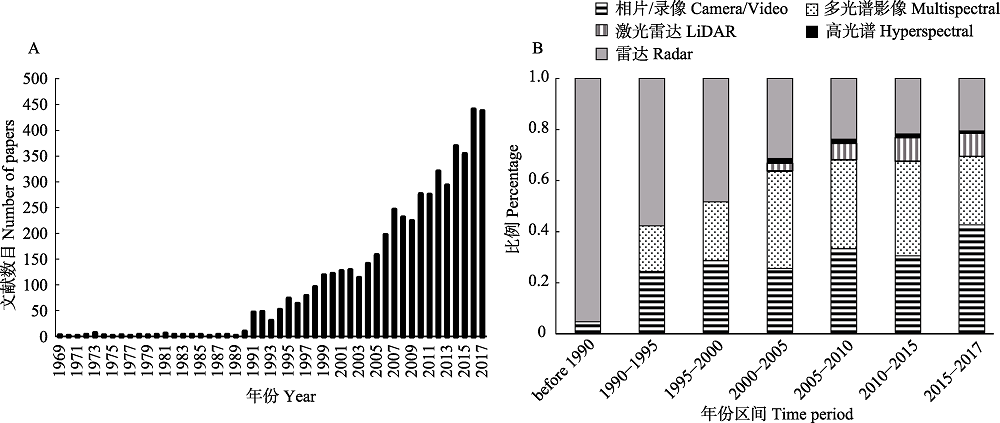
Fig. 1 The yearly number of avian ecological researches with remote sensing (A) and the application proportion of different remote sensing technology in bird ecological study (B)
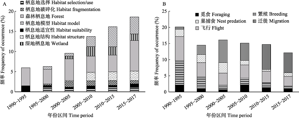
Fig. 2 The key words analysis of avian ecological research with remote sensing according to the core database in Web of Science. A: Habitat study; B: Bird behavior study.
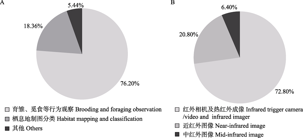
Fig. 3 The proportion of application types of infrared image in bird ecological research. A, Application field; B, Application band.
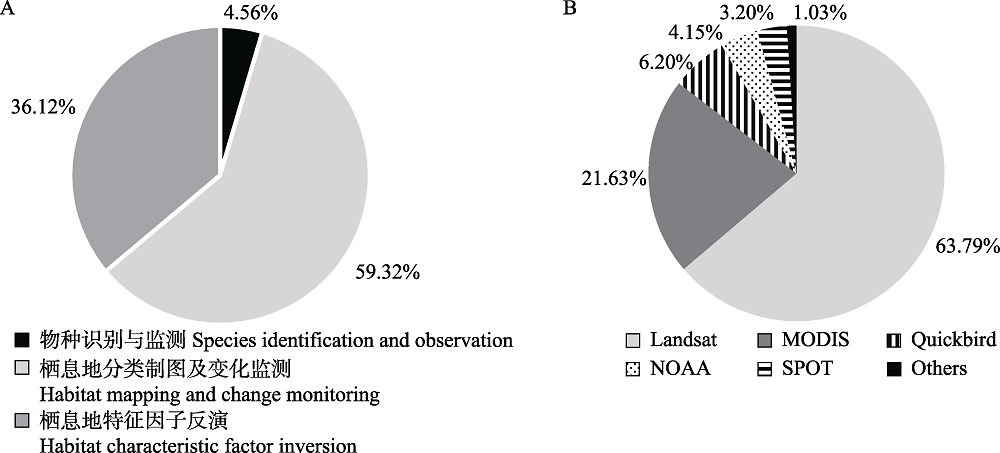
Fig. 4 The proportion of application types of multispectral image data in bird ecological research. A, Application field; B, Common remote sensing sensors.
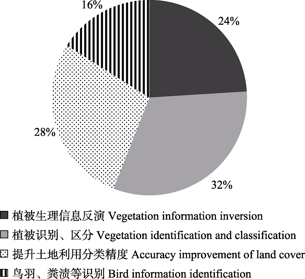
Fig. 5 The proportion of application types of hyperspectral data in bird ecological research
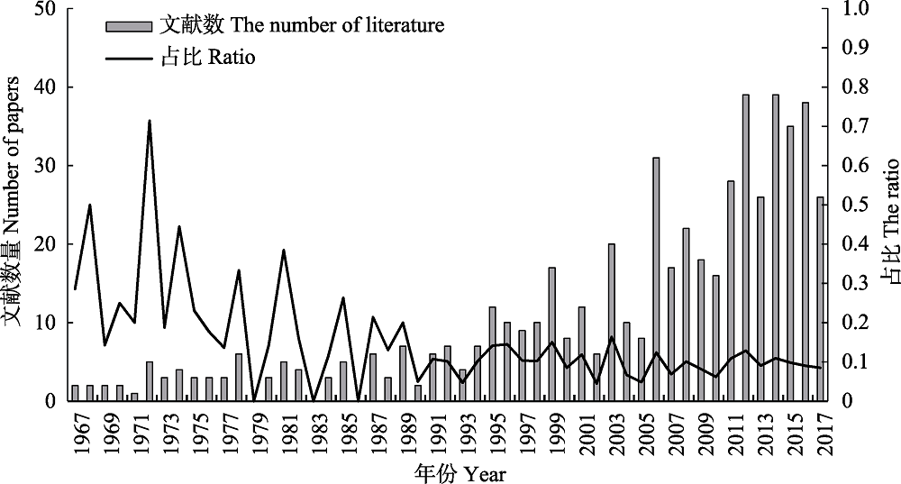
Fig. 6 The yearly quantity of publications of bird ecological study with radar and the proportion in of radar in all articles with remote sensing
| [1] | Abd-Elrahman A (2005) Development of pattern recognition algorithm for automatic bird detection from unmanned aerial vehicle imagery. Surveying and Land Information Science, 65, 37-45. |
| [2] | Alerstam T, Chapman JW, Backman J, Smith AD, Karlsson H, Nilsson C, Reynolds DR, Klaassen Raymond HG, Hill JK (2011) Convergent patterns of long-distance nocturnal migration in noctuid moths and passerine birds. Proceedings of the Royal Society B: Biological Sciences, 278, 3074-3080. |
| [3] | Alerstam T, Rosen M, Backman J, Ericson PGP, Hellgren O (2007) Flight speeds among bird species: Allometric and phylogenetic effects. PLoS Biology, 5, 1656-1662. |
| [4] | Avery MI, Haines-Young RH (1990) Population estimates for the dunlin Calidris alpina derived from remotely sensed satellite imagery of the Flow Country of northern Scotland. Nature, 344, 860-862. |
| [5] | Boerner WM, Yamaguchi Y (2008) Recent advances in POL-SAR & POL-IN-SAR imaging of natural habitats and wetland remote sensing. In: Geoscience and Remote Sensing Symposium, pp. 293-294. IGARSS 2008, IEEE International. |
| [6] | Bolca M, Özen F, Güneş A (2014) Land use changes in Gediz Delta (Turkey) and their negative impacts on wetland habitats. Journal of Coastal Research, 30, 756-764. |
| [7] | Boren JC, Engle DM, Palmer MW, Masters RE, Criner T (1999) Land use change effects on breeding bird community composition. Journal of Range Management, 52, 420-430. |
| [8] | Bradbury RB, Hill RA, Mason DC, Hinsley SA, Wilson JD, Balzter H, Anderson GQA, Whittingham MJ, Davenport IJ, Bellamy PE (2005) Modelling relationships between birds and vegetation structure using airborne LiDAR data: A review with case studies from agricultural and woodland environments. Ibis, 147, 443-452. |
| [9] | Broughton RK, Hill RA, Freeman SN, Bellamy PE, Hinsley SA (2012) Describing habitat occupation by woodland birds with territory mapping and remotely sensed data: An example using the marsh tit (Poecile palustris). Condor, 114, 812-822. |
| [10] | Bruderer B, Boldt A (2001) Flight characteristics of birds: Radar measurements of speeds. Ibis, 143, 178-204. |
| [11] | Brydegaard M, Samuelsson P, Kudenov MW, Svanberg S (2013) On the exploitation of mid-infrared iridescence of plumage for remote classification of nocturnal migrating birds. Applied Spectroscopy, 67, 477-490. |
| [12] | Buermann W, Saatchi S, Smith TB, Zutta BR, Chaves JA, Mila B, Graham CH (2008) Predicting species distributions across the Amazonian and Andean regions using remote sensing data. Journal of Biogeography, 35, 1160-1176. |
| [13] | Buler JJ, Randall LA, Fleskes JP, Barrow WC, Bogart T, Kluver D (2012) Mapping wintering waterfowl distributions using weather surveillance radar. PLoS ONE, 7. |
| [14] | Chen SG, Zhang TL (2015) Evaluation of a QAA-based algorithm using MODIS land bands data for retrieval of IOPs in the eastern China Seas. Optics Express, 23, 13953-13971. |
| [15] | Chen SP (1990) Dictionary of Remote Sensing. Science Press, Beijing. |
| [陈述彭 (1990) 遥感大词典. 科学出版社, 北京.] | |
| [16] | Chen WS, Li J (2011) Review on development and applications of avian radar technology. Modern Radar, 39, 7-17. (in Chinese with English abstract) |
| [陈唯实, 李敬 (2017) 雷达探鸟技术发展与应用综述. 现代雷达, 39, 7-17.] | |
| [17] | Christie KS, Gilbert SL, Brown CL, Hatfield M, Hanson L (2016) Unmanned aircraft systems in wildlife research: Current and future applications of a transformative technology. Frontiers in Ecology and the Environment, 14, 241-251. |
| [18] | Clawges R, Vierling K, Vierling L, Rowell E (2008) The use of airborne LiDAR to assess avian species diversity, density, and occurrence in a pine/aspen forest. Remote Sensing of Environment, 112, 2064-2073. |
| [19] | Cornforth WA, Fatoyinbo TE, Freemantle TP, Pettorelli N (2013) Advanced land observing satellite phased array type L-band SAR (ALOS PALSAR) to inform the conservation of mangroves: Sundarbans as a case study. Remote Sensing, 5, 224-237. |
| [20] | Costa M, Araujo LE, Shaw A, Steckler C, Hill P (2007) Hyperspectral imagery for mapping intertidal vegetation at Roberts Bank tidal flats, British Columbia, Canada. Canadian Journal of Remote Sensing, 33, 130-141. |
| [21] | Cui LJ, Fei T, Qi Q, Liu YL, Wu GF (2013) Estimating Carex quality with laboratory-based hyperspectral measurements. International Journal of Remote Sensing, 34, 1866-1878. |
| [22] | Cushman SA, Mcgarigal K (2002) Hierarchical, multi-scale decomposition of species-environment relationships. Landscape Ecology, 17, 637-646. |
| [23] | Dabrowska-Zielinska K, Gruszczynska M, Lewinski S, Hoscilo A, Bojanowski J (2009) Application of remote and in situ information to the management of wetlands in Poland. Journal of Environmental Management, 90, 2261-2269. |
| [24] | Daily GC, Ehrlich PR, Sanchez-Azofeifa GA (2001) Countryside biogeography: Use of human-dominated habitats by the avifauna of southern Costa Rica. Ecological Applications, 11, 1-13. |
| [25] | Delord K, Roudaut G, Guinet C, Barbraud C, Bertrand S, Weimerskirch H (2015) Kite aerial photography: A low-cost method for monitoring seabird colonies. Journal of Field Ornithology, 86, 173-179. |
| [26] | Diehl RH, Larkin RP, Black JE (2003) Radar observations of bird migration over the Great Lakes. Auk, 120, 278-290. |
| [27] | Dodge S, Bohrer G, Bildstein K, Davidson SC, Weinzierl R, Bechard MJ, Barber D, Kays R, Brandes D, Han J (2014) Environmental drivers of variability in the movement ecology of turkey vultures (Cathartes aura) in North and South America. Philosophical Transactions of the Royal Society of London, 369, 20130195. |
| [28] | Dwyer RG, Bearhop S, Campbell HA, Bryant DM (2013) Shedding light on light: Benefits of anthropogenic illumination to a nocturnally foraging shorebird. Journal of Animal Ecology, 82, 478-485. |
| [29] | Evans KL, Newson SE, Gaston KJ (2009) Habitat influences on urban avian assemblages. Ibis, 151, 19-39. |
| [30] | Farnsworth A, Van-Doren BM, Hochachka WM, Sheldon D, Winner K, Irvine J, Geevarghese J, Kelling S (2016) A characterization of autumn nocturnal migration detected by weather surveillance radars in the northeastern USA. Ecological Applications, 26, 752-770. |
| [31] | Ferraz SFD, Capao L, Vettorazzi CA (2006) Temporal scale and spatial resolution effects on Amazon forest fragmentation assessment in Rondonia. International Journal of Remote Sensing, 27, 459-472. |
| [32] | Fensholt R, Rasmussen K, Nielsen TT, Mbow C (2009) Evaluation of earth observation based long term vegetation trends - Intercomparing NDVI time series trend analysis consistency of Sahel from AVHRR GIMMS, Terra MODIS and SPOT VGT data. Remote Sensing of Environment, 113, 1886-1898. |
| [33] | Fretwell PT, Scofield P, Phillips RA (2017) Using super-high resolution satellite imagery to census threatened albatrosses. Ibis, 159, 481-490. |
| [34] | Fretwell PT, Trathan PN (2009) Penguins from space: Faecal stains reveal the location of Emperor penguin colonies. Global Ecology and Biogeography, 18, 543-552. |
| [35] | Fuller DO (2001) Forest fragmentation in Loudoun County, Virginia, USA evaluated with multitemporal Landsat imagery. Landscape Ecology, 16, 627-642. |
| [36] | Gauthreaux SA, Belser CG (2003) Radar ornithology and biological conservation. Auk, 120, 266-277. |
| [37] | Gilbert M, Newman SH, Takekawa JY, Loth L, Biradar C, Prosser DJ, Balachandran S, Rao MV, Mundkur T, Yan BP, Xing Z, Hou YS, Batbayar N, Natsagdorj T, Hogerwerf L, Slingenbergh J, Xiao XM (2010) Flying over an infected landscape: Distribution of highly pathogenic avian influenza H5V1 risk in south Asia and satellite tracking of wild waterfowl. Ecohealth, 7, 448-458. |
| [38] | Goel NS, Thompson RL (1984) Inversion of vegetation canopy reflectance models for estimating agronomic variables. 5. Estimation of leaf-area index and average leaf angle using measured canopy reflectances. Remote Sensing of Environment, 16, 69-85. |
| [39] | Goetz SJ, Steinberg D, Betts MG, Holmes RT, Doran PJ, Dubayah R, Hofton M (2010) LiDAR remote sensing variables predict breeding habitat of a Neotropical migrant bird. Ecology, 91, 1569-1576. |
| [40] | Goetz SJ, Sun M, Zolkos S, Hansen A, Dubayah R (2014) The relative importance of climate and vegetation properties on patterns of North American breeding bird species richness. Environmental Research Letters, 9, 2033-2053. |
| [41] | Gong P, Pu R, Yu B (1997) Conifer species recognition: An exploratory analysis of in situ hyperspectral data. Remote sensing of Environment, 62, 189-200. |
| [42] | Goodenough DG, Chen H, Gordon P, Niemann KO, Quinn G (2012) Forest applications with hyperspectral imaging. In: 2012 IEEE International Geoscience and Remote Sensing Symposium, pp. 7309-7312. IEEE, Piscataway. |
| [43] | Gordo O (2007) Why are bird migration dates shifting? A review of weather and climate effects on avian migratory phenology. Climate Research, 35, 37-58. |
| [44] | Groom G, Stjernholm M, Nielsen RD, Fleetwood A, Petersen IK (2013) Remote sensing image data and automated analysis to describe marine bird distributions and abundances. Ecological Informatics, 14, 2-8. |
| [45] | Guo DF, Zang SY, Na XD (2015) Habitat suitability evaluation of red-crowned crane in Zhalong National Nature Reserve. Geography and Geo-Informaion Science, 31, 54-58. (in Chinese with English abstract) |
| [郭殿繁, 臧淑英, 那晓东 (2015) 扎龙保护区丹顶鹤栖息地适宜性评价. 地理与地理信息科学, 31, 54-58.] | |
| [46] | Guo QH, Liu J, Li YM, Zhai QP, Wang YC, Wu FF, Hu TY, Wan HW, Liu HM, Shen WM (2016) Perspectives and prospects of unmanned aerial vehicle in remote sensing monitoring of biodiversity. Biodiversity Science, 24, 1249-1266. (in Chinese with English abstract) |
| [郭庆华, 刘瑾, 李玉美, 翟秋萍, 王永财, 吴芳芳, 胡天宇, 万华伟, 刘慧明, 申文明 (2016) 生物多样性近地面遥感监测: 应用现状与前景展望. 生物多样性, 24, 1249-1266.] | |
| [47] | Haywood A, Stone C (2011) Mapping eucalypt forest susceptible to dieback associated with bell miners (Manorina melanophys) using laser scanning, SPOT 5 and ancillary topographical data. Ecological Modelling, 222, 1174-1184. |
| [48] | Higuchi H, Pierre JP, Krever V, Andronov V, Fujita G, Ozaki K (2004) Using a remote technology in conservation: Satellite tracking white-naped cranes in Russia and Asia. Conservation Biology, 18, 136-147. |
| [49] | Hill RA, Hinsley SA (2015) Airborne ldar for woodland habitat quality monitoring: Exploring the significance of LiDAR data characteristics when modelling organism-habitat relationships. Remote Sensing, 7, 3446-3466. |
| [50] | Hüppop O, Dierschke J, Exo KM, Fredrich E, Hill R (2006) Bird migration studies and potential collision risk with offshore wind turbines. Ibis, 148, 90-109. |
| [51] | Hu YB, Zhao QS, Lou YQ, Chen LJ, Antonio GM, Sun YH (2017) Parental attendance of Chestnut Thrush reduces nest predation during the incubation period: Compensation for low nest concealment? Journal of Ornithology, 158, 1111-1117. |
| [52] | Jiang HX, Liu CY, Hou YQ, Qian FW (2010) Application of RS, GIS and GPS techniques in study of avian habitat. Scientia Silvae Sinicae, 46, 155-163. (in Chinese with English abstract) |
| [江红星, 刘春悦, 侯韵秋, 钱法文 (2010) 3S技术在鸟类栖息地研究中的应用. 林业科学, 46, 155-163.] | |
| [53] | Jones GP, Pearlstine LG, Percival HF (2006) An assessment of small unmanned aerial vehicles for wildlife research. Wildlife Society Bulletin, 34, 750-758. |
| [54] | Jung JF, Combs DL, Sowl KM (2016) Habitat selection by bristle-thighed curlews (Numenius tahitiensis) breeding within the Southern Nulato Hills, Alaska. Wilson Journal of Ornithology, 128, 727-737. |
| [55] | Karaman M, Budakoglu M, Avci DU, Ozelkan E, Bulbul A, Civas M, Tasdelen S (2015) Determination of seasonal changes in wetlands using CHRIS/Proba hyperspectral satellite images: A case study from Acigol (Denizli), Turkey. Journal of Environmental Biology, 36, 73-83. |
| [56] | Kerr JT, Isabelle D (2010) Habitat loss and the limits to endangered species recovery. Ecology Letters, 7, 1163-1169. |
| [57] | Lagos NA, Paolini P, Jaramilo E, Lovengree C, Duarte C, Contreras H (2008) Environmental processes, water quality degradation, and decline of waterbird populations in the Rio Cruces Wetland, Chile. Wetlands, 28, 938-950. |
| [58] | Lefsky MA, Cohen WB, Acker SA, Parker GG, Spies TA, Harding D (1999) LiDAR remote sensing of the canopy structure and biophysical properties of Douglas-fir western hemlock forests. Remote Sensing of Environment, 70, 339-361. |
| [59] | Lefsky MA, Cohen WB, Parker GG, Harding DJ (2002) LiDAR remote sensing for ecosystem studies. Bioscience, 52, 19-30. |
| [60] | Legleiter CJ, Roberts DA, Marcus WA, Fonstad MA (2004) Passive optical remote sensing of river channel morphology and in-stream habitat: Physical basis and feasibility. Remote Sensing of Environment, 93, 493-510. |
| [61] | Lesak AA, Radeloff VC, Hawbaker TJ, Pidgeon AM, Gobakken T, Contrucci K (2011) Modeling forest songbird species richness using LiDAR-derived measures of forest structure. Remote Sensing of Environment, 115, 2823-2835. |
| [62] | Li XW, Wang YT (2013) Prospects on future developments of quantitative remote sensing. Acta Geographica Sinica, 68, 1163-1169. (in Chinese with English abstract) |
| [李小文, 王祎婷(2013) 定量遥感尺度效应刍议. 地理学报, 68, 1163-1169.] | |
| [63] | Liu CY, Jiang HX, Zhang SQ, Hou YQ, Lu J (2012) Breeding habitat characteristics of red-crowned crane at Zhalong of Northeast China: A multi-scale approach based on TM and ASAR image data. Chinese Journal of Applied Ecology, 23, 491-498. ( in Chinese with English abstract) |
| [刘春悦, 江红星, 张树清, 侯韵秋, 陆军 (2012) 基于TM与ASAR遥感数据的扎龙丹顶鹤繁殖栖息地多尺度特征. 应用生态学报, 23, 491-498.] | |
| [64] | Lynch HJ, Schwaller MR (2014) Mapping the abundance and distribution of Adelie penguins using Landsat-7: First steps towards an integrated multi-sensor pipeline for tracking populations at the continental scale. PLoS ONE,9, 11, e113301. |
| [65] | Lyzenga DR (1978) Passive remote sensing techniques for mapping water depth and bottom features. Applied Optics, 17, 379-383. |
| [66] | Marticardona B, Steissberg TE, Schladow SG, Hook SJ (2008) Relating fish kills to upwellings and wind patterns in the Salton Sea. Hydrobiologia, 604, 85-95. |
| [67] | Martin ME, Newman SD, Aber JD, Congalton RG (1998) Determining forest species composition using high spectral resolution remote sensing data. Remote Sensing of Environment, 65, 249-254. |
| [68] | Martinuzzi S, Vierling LA, Gould WA, Falkowski MJ, Evans JS, Hudak AT, Vierling KT (2009) Mapping snags and understory shrubs for a LiDAR-based assessment of wildlife habitat suitability. Remote Sensing of Environment, 113, 2533-2546. |
| [69] | Mayer PM, Smith LM, Ford RG, Watterson DC, McCutchen MD, Ryan MR (2009) Nest construction by a ground- nesting bird represents a potential trade-off between egg crypticity and thermoregulation. Oecologia, 159, 893-901. |
| [70] | Mexicano L, Nagler PL, Zamora-Arrroyo F, Glenn EP (2013) Vegetation dynamics in response to water inflow rates and fire in a brackish Typha domingensis Pers. marsh in the delta of the Colorado River, Mexico. Ecological Engineering, 59, 167-175. |
| [71] | Mei AX (2001) Remote Sensing Introduction. Higher Education Press, Beijing. (in Chinese) |
| [梅安新 (2001) 遥感导论. 高等教育出版社, 北京.] | |
| [72] | Meng B, Wang JF (2005) A Review on the methodology of scaling with geo-data. Acta Geographica Sinica, 60, 277-288. (in Chinese with English abstract) |
| [孟斌, 王劲峰 (2005) 地理数据尺度转换方法研究进展. 地理学报, 60, 277-288.] | |
| [73] | Mirzaei G, Jamali MM, Ross J, Gorsevski PV, Bingman VP (2015) Data fusion of acoustics, infrared, and marine radar for avian study. IEEE Sensors Journal, 15, 6625-6632. |
| [74] | O’Connell AF, Nichols JD, Karanth KU (2010) Camera Traps in Animal Ecology: Methods and Analyses. Springer Science and Business Media, New York. |
| [75] | Osborne PE, Alonso JC, Bryant RG (2010) Modelling landscape-scale habitat use using GIS and remote sensing: A case study with great bustards. Journal of Applied Ecology, 38, 458-471. |
| [76] | Pimm SL, Jenkins CN, Abell R, Brooks TM, Gittleman JL, Joppa LN, Raven PH, Roberts CM, Sexton JO (2014) The biodiversity of species and their rates of extinction, distribution, and protection. Science, 344, 1246752. |
| [77] | Pistolesi LI, Ni-Meister W, McDonald KC (2015) Mapping wetlands in the Hudson Highlands ecoregion with ALOS PALSAR: An effort to identify potential swamp forest habitat for golden-winged warblers. Wetlands Ecology and Management, 23, 95-112. |
| [78] | Pradervand JN, Dubuis A, Pellissier L, Guisan A, Randin C (2014) Very high resolution environmental predictors in species distribution models: Moving beyond topography? Progress in Physical Geography, 38, 79-96. |
| [79] | Robinson WD, Bowlin MS, Bisson I, Shamounbaranes J, Thorup K, Diehl RH (2010) Integrating concepts and technologies to advance the study of bird migration. Frontiers in Ecology and the Environment, 8, 354-361. |
| [80] | Rodgers JA, Linda SB, Nesbitt SA (1995) Comparing aerial estimates with ground counts of nests in wood stork colonies. Journal of Wildlife Management, 59, 656-666. |
| [81] | Rodrigues P, Aubrecht C, Gil A, Longcore T, Elvidge C (2012) Remote sensing to map influence of light pollution on Cory’s shearwater São Miguel Island, Azores Archipelago. European Journal of Wildlife Research, 58, 147-155. |
| [82] | Ruan RZ, Feng XZ, She YJ (2007) Fusion of Radarsat SAR and ETM plus imagery for identification of fresh water wetland. In: Geoinformatics 2007: Remotely Sensed Data and Information (eds Ju W, Zhao S), 6752(5), 74. International Society for Optics and Photonics, Nanjing. |
| [83] | Santos MJ, Greenberg JA, Ustin SL (2010) Using hyperspectral remote sensing to detect and quantify southeastern pine senescence effects in red-cockaded woodpecker (Picoides borealis) habitat. Remote Sensing of Environment, 114, 1242-1250. |
| [84] | Sasamal SK, Chaudhury SB, Samal RN, Pattanaik AK (2008) QuickBird spots flamingos off Nalabana Island, Chilika Lake, India. International Journal of Remote Sensing, 29, 4865-4870. |
| [85] | Schwaller MR, Olson J, Charles E, Ma ZQ, Zhu ZL, Dahmer P (1989) A remote sensing analysis of Adelie penguin rookeries. Remote Sensing of Environment, 28, 199-206. |
| [86] | Schwaller MR, Southwell CJ, Emmerson LM (2013) Continental-scale mapping of Adélie penguin colonies from Landsat imagery. Remote Sensing of Environment, 139, 353-364. |
| [87] | She XY, Ke CQ, Miao X, Zhang X, Zhang J (2017) An automated method for the detection of emperor penguin colonies from Landsat 8 imagery. Remote Sensing Letters, 8, 596-605. |
| [88] | Shirley SM, Yang Z, Hutchinson RA, Alexander JD, Mcgarigal K, Betts MG (2013) Species distribution modelling for the people: Unclassified landsat TM imagery predicts bird occurrence at fine resolutions. Diversity and Distributions, 19, 855-866. |
| [89] | Shi ZL, Cao M (2007) A study of surveying and mapping of island and tidal flat based on LiDAR. Bulletin of Surveying and Mapping, (5), 49-53. (in Chinese) |
| [史照良, 曹敏 (2007) 基于LiDAR技术的海岛礁、滩涂测绘研究. 测绘通报, (5), 49-53.] | |
| [90] | Singh M, Tokola T, Hou Z, Notarnicola C (2017) Remote sensing-based landscape indicators for the evaluation of threatened-bird habitats in a tropical forest. Ecology and Evolution, 7, 4552. |
| [91] | Su LH, Li XW, Huang YX (2001) An review on scale in remote sensing. Advanced in Earth Science, 16, 544-548. (in Chinese with English abstract) |
| [苏理宏, 李小文, 黄裕霞 (2001) 遥感尺度问题研究进展. 地球科学进展, 16, 544-548.] | |
| [92] | Suryan R, Santora J, Sydeman W (2012) New approach for using remotely sensed chlorophyll a to identify seabird hotspots. Marine Ecology Progress, 451, 213-225. |
| [93] | Taft OW, Haig SM, Kiilsgaard C (2003) Use of radar remote sensing (RADARSAT) to map winter wetland habitat for shorebirds in an agricultural landscape. Environmental Management, 32, 268-281. |
| [94] | Tebbs EJ, Remedios JJ, Avery ST, Harper DM (2013) Remote sensing the hydrological variability of Tanzania’s Lake Natron, a vital Lesser Flamingo breeding site under threat. Ecohydrology and Hydrobiology, 13, 148-158. |
| [95] | Tøttrup AP, Thorup K, Rainio K, Yosef R, Lehikoinen E, Rahbek C (2008) Avian migrants adjust migration in response to environmental conditions en route. Biology Letters, 4, 685. |
| [96] | Tran A, Goutard F, Chamaillé L, Baghdadi N, Seen DL (2010) Remote sensing and avian influenza: A review of image processing methods for extracting key variables affecting avian influenza virus survival in water from Earth Observation satellites. International Journal of Applied Earth Observation and Geoinformation, 12, 1-8. |
| [97] | Turner W, Spector S, Gardiner N, Fladeland M, Sterling E, Steininger M (2003) Remote sensing for biodiversity science and conservation. Trends in Ecology and Evolution, 18, 306-314. |
| [98] | Tuttle EM, Jensen RR, Formica VA, Gonser RA (2006) Using remote sensing image texture to study habitat use patterns: A case study using the polymorphic white-throated sparrow (Zonotrichia albicollis). Global Ecology and Biogeography, 15, 349-357. |
| [99] | Vanhellemont Q, Ruddick K (2014) Turbid wakes associated with offshore wind turbines observed with Landsat 8. Remote Sensing of Environment, 145, 105-115. |
| [100] | Vas E, Lescroel A, Duriez O, Boguszewski G, Gremillet D (2015) Approaching birds with drones: First experiments and ethical guidelines. Biology Letters, 11, 20140754. |
| [101] | Wang XQ, Wang MM, Wang SQ, Wu YD (2015) Extraction of vegetation information from visible unmanned aerialvehicle images. Transactions of the Chinese Society of Agricultural Engineering, 31,152-159. (in Chinese with English abstract) |
| [汪小钦, 王苗苗, 王绍强, 吴云东 (2015) 基于可见光波段无人机遥感的植被信息提取. 农业工程学报, 31, 152-159.] | |
| [102] | Wang Y, Zhang ZW, Zheng GM, Li JQ, Xu JL, Ma ZJ, Biancucci AL (2012) Ornithological research: Past twenty years and future perspectives in China. Biodiversity Science, 20, 119-137. (in Chinese with English abstract) |
| [王勇, 张正旺, 郑光美, 李建强, 徐基良, 马志军, Biancucci AL (2012) 鸟类学研究: 过去二十年的回顾和对中国未来发展的建议. 生物多样性, 20, 119-137.] | |
| [103] | Weber PT, Nohara TJ (2011) Device and method for 3D height-finding avian radar. US. Patent No. 7, 864, 103. US Patent and Trademark Office, Washington, DC. |
| [104] | Weissensteiner MH, Poelstra JW, Wolf JBW (2015) Low- budget ready-to-fly unmanned aerial vehicles: An effective tool for evaluating the nesting status of canopy-breeding bird species. Journal of Avian Biology, 46, 425-430. |
| [105] | Wilson AM, Jetz W (2016) Remotely sensed high-resolution global cloud dynamics for predicting ecosystem and biodiversity distributions. PLoS Biology, 14, e1002415. |
| [106] | Wilson JW, Weckwerth TM, Vivekanandan J, Wakimoto RM, Russell RW (1994) Boundary-layer clear-air radar echoes: Origin of echoes and accuracy of derived winds. Journal of Atmospheric and Oceanic Technology, 11, 1184-1206. |
| [107] | Wood EM, Pidgeon AM, Radeloff VC, Keuler NS (2012) Image texture as a remotely sensed measure of vegetation structure. Remote Sensing of Environment, 121, 516-526. |
| [108] | Wu BF, Zhang M (2017) Remote sensing: Oberservations to data products. Acta Geographica Sinica, 72, 2093-2111. (in Chinese with English abstract) |
| [吴炳方, 张淼 (2017) 从遥感观测数据到数据产品. 地理学报, 72, 2093-2111.] | |
| [109] | Wu J, Jones KB, Li H, Loucks OL (2006) Scaling and uncertainty Analysis in Ecology. Springer, Dordrecht. |
| [110] | Zellweger F, Braunisch V, Baltensweiler A, Bollmann K (2013) Remotely sensed forest structural complexity predicts multi species occurrence at the landscape scale. Forest Ecology and Management, 307, 303-312. |
| [111] | Zhang N (2006) Scale issues in ecology: Concepts of scale and scale analysis. Acta Ecologica Sinica, 26, 2340-2355. (in Chinese with English abstract) |
| [张娜 (2006) 生态学中的尺度问题: 内涵与分析方法. 生态学报, 26, 2340-2355.] | |
| [112] | Zhao YM, Li YH, Shang YN, Li J, Yu Y, Li LH (2014) Application and development direction of LiDAR. Journal of Telemetry,Tracking and Command, 35, 4-22. (in Chinese with English abstract) |
| [赵一鸣, 李艳华, 商雅楠, 李静, 于勇, 李凉海 (2014) 激光雷达的应用及发展趋势. 遥测遥控, 35, 4-22.] | |
| [113] | Zhao YS (2013)Principle and Method of Remote Sensing Application Analysis. Science Press, Beijing. (in Chinese) |
| [赵英时 (2013) 遥感应用分析原理与方法. 科学出版社, 北京.] | |
| [114] | Zhao YZ, Wang ZC, Xu JL, Luo X, An LD (2013) Activity rhythm and behavioral time budgets of wild reeves's pheasant (Syrmaticus reevesii) using infrared camera. Acta Ecologica Sinica, 33, 6021-6027. (in Chinese with English abstract) |
| [赵玉泽, 王志臣, 徐基良, 罗旭, 安丽丹 (2013) 利用红外照相技术分析野生白冠长尾雉活动节律及时间分配. 生态学报, 33, 6021-6027.] | |
| [115] | Zohmann M, Pennerstorfer J, Nopp-Mayr U (2013) Modelling habitat suitability for alpine rock ptarmigan (Lagopus muta helvetica) combining object-based classification of IKONOS imagery and Habitat Suitability Index modelling. Ecological Modelling, 254, 22-32. |
| [1] | Zhehan Chen, Jin Yin, Ji Ye, Dongwei Liu, Zikun Mao, Shuai Fang, Fei Lin, Xugao Wang. Effects of simulated warming on seasonal dynamics of herbaceous diversity in temperate secondary forests in Northeast China [J]. Biodiv Sci, 2023, 31(5): 23059-. |
| [2] | Xin Yang, Zhiliang Yao, Bin Wang, Handong Wen, Yun Deng, Min Cao, Zhiming Zhang, Zhenghong Tan, Luxiang Lin. Driving effects of forest stand structure of a subtropical evergreen broad-leaved forest on species composition variation: From local to regional scales [J]. Biodiv Sci, 2023, 31(2): 22139-. |
| [3] | Jiesheng Rao, Tao Yang, Xi Tian, Wencong Liu, Xiaofeng Wang, Hengjun Qian, Zehao Shen. Vertical structural characteristics of a semi-humid evergreen broad-leaved forest and common tree species based on a portable backpack LiDAR [J]. Biodiv Sci, 2023, 31(11): 23216-. |
| [4] | Dong Wang, Qinggaowa Sai, Zihan Wang, Hongxiu Zhao, Xinming Lian. Spatiotemporal overlap among sympatric Pallas’s cat (Otocolobus manul), Tibetan fox (Vulpes ferrilata) and red fox (V. vulpes) in the source region of the Yangtze River [J]. Biodiv Sci, 2022, 30(9): 21365-. |
| [5] | Yan Xu, Congling Zhang, Ruijiao Jiang, Zifei Wang, Mengchen Zhu, Guochun Shen. UAV-based hyperspectral images and monitoring of canopy tree diversity [J]. Biodiv Sci, 2021, 29(5): 647-660. |
| [6] | Dong Wang, Yaqiong Wan, Shizhao Wang, Jiaping Chen, Tong Wu, Jiaqi Li, Xinming Lian. Camera-trapping survey of the diversity of mammals and birds in the Tuotuo River basin of the source region of the Yangtze River [J]. Biodiv Sci, 2020, 28(9): 1132-1140. |
| [7] | Ruchuan He, Lin Wang, Ruichang Quan. Introduction to Transboundary Animal Diversity Monitoring Platform of Southern Yunnan, China and Southeast Asia [J]. Biodiv Sci, 2020, 28(9): 1097-1103. |
| [8] | Peng Liu, Mingxia Fu, Dunwu Qi, Xinqiang Song, Wei Wei, Wanjing Yang, Yuxiang Chen, Yanshan Zhou, Jiabin Liu, Rui Ma, Ji Yu, Hong Yang, Peng Chen, Rong Hou. Camera-trapping survey of wild mammals and birds in Daxiangling Nature Reserve, Sichuan Province [J]. Biodiv Sci, 2020, 28(7): 905-912. |
| [9] | Weihe Yang,Yuelong Chen,Yue Deng,Xingzhe Wang,Lijun Chen,Daming Hu,Xiuhai Luo,Dazhao Song,Zhishu Xiao. Preliminary surveys of mammals and birds by infrared camera traps in the Sichuan Baishuihe National Nature Reserve [J]. Biodiv Sci, 2019, 27(9): 1012-1015. |
| [10] | Mu Jun, Wang Jiaojiao, Zhang Lei, Li Yunbo, Li Zhumei, Su Haijun. Field monitoring using infrared cameras and activity rhythm analysis on mammals and birds in Xishui National Nature Reserve, Guizhou, China [J]. Biodiv Sci, 2019, 27(6): 683-688. |
| [11] | Chen Lijun,Shu Zufei,Xiao Zhishu. Application of camera-trapping data to study daily activity patterns of Galliformes in Guangdong Chebaling National Nature Reserve [J]. Biodiv Sci, 2019, 27(3): 266-272. |
| [12] | Qinghua Guo, Tianyu Hu, Yuanxi Jiang, Shichao Jin, Rui Wang, Hongcan Guan, Qiuli Yang, Yumei Li, Fangfang Wu, Qiuping Zhai, Jin Liu, Yanjun Su. Advances in remote sensing application for biodiversity research [J]. Biodiv Sci, 2018, 26(8): 789-806. |
| [13] | Zhongyi Zhou, Ran Liu, Shuna Shi, Yanjun Su, Wenkai Li, Qinghua Guo. Ecological niche modeling with LiDAR data: A case study of modeling the distribution of fisher in the southern Sierra Nevada Mountains, California [J]. Biodiv Sci, 2018, 26(8): 878-891. |
| [14] | Cheng Tian,Junqing Li,Xuyu Yang,Lin Yu,Dan Yuan,Yunxi Li. Preliminary surveys of wild animals using infrared camera in Wanglang National Nature Reserve, Sichuan Province [J]. Biodiv Sci, 2018, 26(6): 620-626. |
| [15] | Binqiang Li, Pengying Li, Jiawei Yang, Hongjun Zi, Xingquan Li, Xihuan Duan, Xu Luo. Wildlife monitoring in Weishan Qinghua Green Peafowl Nature Reserve using infrared cameras, Yunnan Province [J]. Biodiv Sci, 2018, 26(12): 1343-1347. |
| Viewed | ||||||
|
Full text |
|
|||||
|
Abstract |
|
|||||
Copyright © 2022 Biodiversity Science
Editorial Office of Biodiversity Science, 20 Nanxincun, Xiangshan, Beijing 100093, China
Tel: 010-62836137, 62836665 E-mail: biodiversity@ibcas.ac.cn ![]()