
Biodiv Sci ›› 2011, Vol. 19 ›› Issue (1): 71-78. DOI: 10.3724/SP.J.1003.2011.08080
Special Issue: 青藏高原生物多样性与生态安全
• Special Issue • Previous Articles Next Articles
Bo Ma1, Xiaoming Wang1,3, Xiaoqing Liu1, Zhenghuan Wang1,2,*( )
)
Received:2010-04-03
Accepted:2010-09-26
Online:2011-01-20
Published:2011-04-01
Contact:
Zhenghuan Wang
Bo Ma, Xiaoming Wang, Xiaoqing Liu, Zhenghuan Wang. GIS analysis of the spatial relationship between plateau pika burrow distribution and vegetation distributional patterns[J]. Biodiv Sci, 2011, 19(1): 71-78.
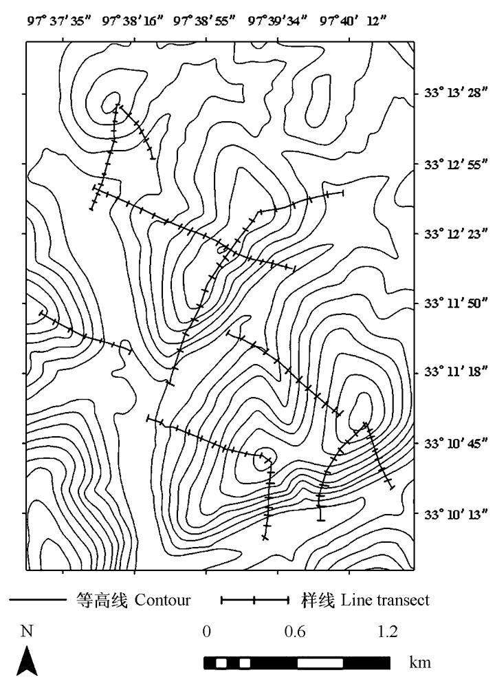
Fig. 1 Line transects distribution in the study area in Yunbo Gou, Shiqu County, Sichuan Province
| NDVI分级 NDVI groups | NDVI均值 Mean value of each NDVI group (± SD) | 像元数 Number of pixels | 各级像元所占比率 Percentage of pixels in each group (%) |
|---|---|---|---|
| 0.1-0.2 | 0.164 ± 0.029 | 3,166 | 2.8 |
| 0.2-0.3 | 0.266 ± 0.025 | 19,978 | 17.4 |
| 0.3-0.4 | 0.353 ± 0.029 | 47,482 | 41.4 |
| 0.4-0.5 | 0.440 ± 0.024 | 43,305 | 37.8 |
| 0.5-0.6 | 0.510 ± 0.079 | 639 | 0.6 |
| 总数 Total | 0.366 ± 0.076 | 114,570 | 100 |
Table 1 The distribution of NDVI values in the study area in Yunbo Gou, Shiqu County.
| NDVI分级 NDVI groups | NDVI均值 Mean value of each NDVI group (± SD) | 像元数 Number of pixels | 各级像元所占比率 Percentage of pixels in each group (%) |
|---|---|---|---|
| 0.1-0.2 | 0.164 ± 0.029 | 3,166 | 2.8 |
| 0.2-0.3 | 0.266 ± 0.025 | 19,978 | 17.4 |
| 0.3-0.4 | 0.353 ± 0.029 | 47,482 | 41.4 |
| 0.4-0.5 | 0.440 ± 0.024 | 43,305 | 37.8 |
| 0.5-0.6 | 0.510 ± 0.079 | 639 | 0.6 |
| 总数 Total | 0.366 ± 0.076 | 114,570 | 100 |
| NDVI分级 NDVI group | 取样单元数 Number of sampling units | 理论比例 Theoretical proportion (Pt)a | 洞穴数观测值 Observed burrow number | 洞穴数期望值 Expected burrow number b | 洞穴数观测值比例 Proportion of observed burrow number in each group (Po)c | 洞穴数观测值比例Bonferroni95%置信区间 95% Bonferroni intervals of Po | 显著性 Significance |
|---|---|---|---|---|---|---|---|
| 0.1-0.2 | 43 | 0.018 | 180 | 293 | 0.011 | 0.009 ≤ Po≤ 0.012 | – |
| 0.2-0.3 | 324 | 0.134 | 1,672 | 2,207 | 0.101 | 0.095 ≤ Po≤ 0.107 | – |
| 0.3-0.4 | 1,082 | 0.446 | 7,246 | 7,372 | 0.439 | 0.429 ≤ Po≤ 0.449 | 0 |
| 0.4-0.5 | 962 | 0.397 | 7,273 | 6,554 | 0.441 | 0.441 ≤ Po≤ 0.449 | + |
| 0.5-0.6 | 12 | 0.005 | 137 | 82 | 0.008 | 0.006 ≤ Po≤ 0.010 | + |
| 总数 Total | 2,423 | 16,508 |
Table 2 Bonferroni z test results of the distribution of active plateau pika burrow numbers in each NDVI group
| NDVI分级 NDVI group | 取样单元数 Number of sampling units | 理论比例 Theoretical proportion (Pt)a | 洞穴数观测值 Observed burrow number | 洞穴数期望值 Expected burrow number b | 洞穴数观测值比例 Proportion of observed burrow number in each group (Po)c | 洞穴数观测值比例Bonferroni95%置信区间 95% Bonferroni intervals of Po | 显著性 Significance |
|---|---|---|---|---|---|---|---|
| 0.1-0.2 | 43 | 0.018 | 180 | 293 | 0.011 | 0.009 ≤ Po≤ 0.012 | – |
| 0.2-0.3 | 324 | 0.134 | 1,672 | 2,207 | 0.101 | 0.095 ≤ Po≤ 0.107 | – |
| 0.3-0.4 | 1,082 | 0.446 | 7,246 | 7,372 | 0.439 | 0.429 ≤ Po≤ 0.449 | 0 |
| 0.4-0.5 | 962 | 0.397 | 7,273 | 6,554 | 0.441 | 0.441 ≤ Po≤ 0.449 | + |
| 0.5-0.6 | 12 | 0.005 | 137 | 82 | 0.008 | 0.006 ≤ Po≤ 0.010 | + |
| 总数 Total | 2,423 | 16,508 |
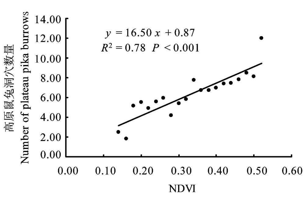
Fig. 2 One-dimensional linear regression between NDVI and the average number of plateau pika burrows in each NDVI group
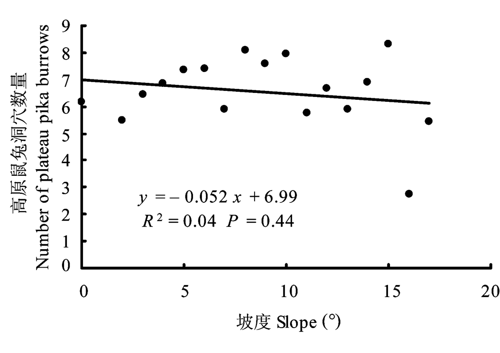
Fig. 3 One-dimensional linear regression between slope and the average number of plateau pika burrows in each slope group
| [1] | Arthur AD, Pech RP, Davey C, Jiebu, Zhang YM, Lin H (2008) Livestock grazing, plateau pikas and the conservation of avian biodiversity on the Tibetan Plateau. Biological Conservation, 141,1972-1981. |
| [2] | Bian JH (边疆晖), Jing ZC (景增春), Fan NC (樊乃昌), Zhou WY (周文扬) (1999) Influence of cover on habitat utilization of plateau pika (Ochotona curzoniae). Acta Theriologica Sinica (兽类学报), 19,212-220. (in Chinese with English abstract) |
| [3] | Collaborating Group for Vegetation of Sichuan (四川植被协作组) (1980) Vegetation of Sichuan Province (四川植被), pp.208-235. Sichuan People’s Publishing House, Chengdu. (in Chinese) |
| [4] | Giraudoux P, Pradier B, Delattre P, Deblay S, Salvi D, Defaut R (1995) Estimation of water vole abundance by using surface indices. Acta Theriologica, 40,77-96. |
| [5] | Giraudoux P, Quere JP, Delattre P, Bao GS, Wang XM, Shi DZ, Vuitton D, Craig PS (1998) Distribution of small mammals along a deforestation gradient in southern Gansu, central China. Acta Theriologica, 43,349-362. |
| [6] | Huete A, Didan K, Miura T, Rodriguez EP, Gao X, Ferreira LG (2002) Overview of the radiometric and biophysical performance of the MODIS vegetation indices. Remote Sensing of Environment, 83,195-213. |
| [7] | Ito TY, Miura N, Lhagvasuren B, Enkhbileg D, Takatsuki S, Tsunekawa A, Jiang Z (2006) Satellite tracking of Mongolian gazelles ( Procapra gutturosa) and habitat shifts in their seasonal ranges. Journal of Zoology, 269,291-298. |
| [8] | Jense JR (translated by Chen XL (陈晓玲), Gong W (龚威), Li PX (李平湘), Tian LQ (田礼乔)) (2007) Introductory Digital Image Processing: A Remote Sensing Perspective (遥感数字影像处理导论), 3rd edn., pp.299-300. China Machine Press, Beijing. (in Chinese) |
| [9] | Jiang ZG (蒋志刚), Xia WP (夏武平) (1987) The niches of yaks, Tibetan sheep and plateau pikas in the alpine meadow ecosystem. Acta Biologica Plateau Sinica (高原生物学集刊), 6,115-146. (in Chinese with English abstract) |
| [10] | Jing ZC (景增春), Wang QJ (王启基), Shi HL (史惠兰), Ma YS (马玉寿), Shi JJ (施建军) (2006) The poison effect experiment of Botulin model D for plateau pikas (Ochotona curzoniae). Pratacultural Science (草业科学), 23(3),89-91. (in Chinese with English abstract) |
| [11] | Komonen M, Komonen A, Otgonsuren A (2003) Daurian pikas ( Ochotona daurica) and grassland condition in eastern Mon- golia. Journal of Zoology, 259,281-288. |
| [12] | Li WJ (李文靖), Zhang YM (张堰铭) (2006) Impacts of plateau pikas on soil organic matter and moisture content in alpine meadow. Acta Theriologica Sinica (兽类学报), 26,331-337. (in Chinese with English abstract) |
| [13] | Liu JK (刘季科), Wang X (王溪), Liu W (刘伟), Nie HY (聂海燕) (1991) Effect of experimental grazing level of Tibetan sheep on rodent communities. In: Alpine Meadow Ecosystem Ⅲ (高寒草甸生态系统, 第3集) (eds Liu JK (刘季科), Wang ZW (王祖望)), pp.9-20. Science Press, Beijing. (in Chinese with English abstract) |
| [14] | Liu JK (刘季科), Wei SW (魏善武), Zhou L (周立), Sha Q (沙渠), Liu Y (刘阳) (1986) A study on the mathematical model for the dynamic of plants and plateau pika system. Acta Biologica Plateau Sinica (高原生物学集刊), 5,45-53. (in Chinese with English abstract) |
| [15] | Liu W (刘伟), Wang X (王溪), Zhou L (周立), Zhou HK (周华坤) (2003) Studies on destruction, prevention and control of plateau pikas in Kobresia pygmaea meadow. Acta Theriologica Sinica (兽类学报), 23,214-219. (in Chinese with English abstract) |
| [16] | Liu W (刘伟), Zhang Y (张毓), Wang X (王溪), Zhao JZ (赵建中), Xu QM (许庆民), Zhou L (周立) (2009) The relationship of the harvesting behavior of plateau pikas with the plant community. Acta Theriologica Sinica (兽类学报), 29,40-49. (in Chinese with English abstract) |
| [17] | Liu QX (刘群秀) (2009) Activity Rhythm, Home Range and Habitat Selection of the Tibetan Fox (藏狐活动规律、家域特征及生境特征的研究). PhD dissertation, School of Life Science, East China Normal University, Shanghai. (in Chinese with English summary). |
| [18] |
Lloret F, Lobo A, Estevan H, Maisongrande P, Vayreda J, Terradas J (2007) Woody plant richness and NDVI response to drought events in Catalonian (northeastern Spain) forests. Ecology, 88,2270-2279.
DOI URL PMID |
| [19] | Marston CG, Armitage RP, Danson FM, Giraudoux P, Ramirez A, Craig PS (2007) Spatio-temporal modelling of small ma- mmal distributions using MODIS NDVI time-series date. Authority Files for ISPRS. http://www.isprs.org/procee-dings/XXXVI/7-C50/P9_Marston_NDVI.pdf. |
| [20] | Neu CW, Byers CR, Peek JM (1974) A technique for analysis of utilization-availability data. The Journal of Wildlife Management, 38,541-545. |
| [21] | Pech RP, Jiebu, Arthur AD, Zhang YM, Lin H (2007) Population dynamics and responses to management of plateau pikas (Ochotona curzoniae). Journal of Applied Ecology, 44,615-624. |
| [22] | Qu JP (曲家鹏), Li KX (李克欣), Yang M (杨敏), Li WJ (李文靖), Zhang YM (张堰铭), Smith AT (2007) Seasonal dynamic pattern of spacial territory in social groups of plateau pikas (Ochotona curzoniae). Acta Theriologica Sinica (兽类学报), 27,215-220. (in Chinese with English abstract) |
| [23] | Quéré JP, Raoul F, Giraudoux P, Delattre P (2000) An index method of estimating relative population densities of the common vole ( Microtus arvalis) at landscape scale. Revue d'écologie, 55,25-32. |
| [24] | Raoul F, Quere JP, Rieffel D, Bernard N, Takahashi K, Scheifler R, Ito A, Wang Q, Qiu JM, Yang W, Craig PS, Giraudoux P (2006) Distribution of small mammals in a pastoral landscape of the Tibetan Plateau (western Sichuan, China) and relationship with grazing practices. Mammalia, 70,214-225. |
| [25] | Retzer V, Reudenbach C (2005) Modelling the carrying capacity and coexistence of pika and livestock in the mountain steppe of the South Gobi, Mongolia. Ecological Modelling, 189,89-104. |
| [26] | Roach WJ, Huntly N, Inouye R (2001) Talus fragmentation mitigates the effects of pikas,Ochotona princeps, on high alpine meadows. Oikos, 92,315-324. |
| [27] | Schaller GB (1998) Wildlife of the Tibetan Steppe, pp.179-185. The University of Chicago Press, Chicago. |
| [28] | Smith AT, Foggin JM (1999) The plateau pika ( Ochotona curzoniae) is a keystone species for biodiversity on the Tibetan Plateau. Animal Conservation, 2,235-240. |
| [29] |
Vaniscotte A, Pleydell DRJ, Raoul F, Quere JP, Qiu JM, Wang Q, Li TY, Bernard N, Coeurdassier M, Delattre P, Takahashi K, Weidmann JC, Giraudoux P (2009) Modelling and spatial discrimination of small mammal assemblages: an example from western Sichuan (China). Ecological Modelling, 220,1218-1231.
DOI URL PMID |
| [30] | Wang MJ (王梦军), Zhong WQ (钟文勤), Wan XR (宛新荣), Wang GH (王广和) (1998) Habitat selection during dispersion of Daurian pika (Ochotona daurica). Acta Zoologica Sinica (动物学报), 44,398-405. (in Chinese with English abstract) |
| [31] | Wang ZH, Wang XM, Lu QB (2007) Selection of land cover by the Tibetan fox Vulpes ferrilata on the eastern Tibetan Plateau, western Sichuan Province, China. Acta Theriologica, 52,215-223. |
| [32] | Wang ZH (王正寰), Wang XM (王小明) (2006) Ecological characteristics of Tibetan fox dens in Shiqu County, Sichuan Province, China. Zoological Research (动物学研究), 27,18-22. (in Chinese with English abstract) |
| [33] | Wang ZW (王祖望), Liu JK (刘季科), Su JP (苏建平), Liu Y (刘阳), Dou FM (窦丰满) (1987) Energy dynamics of small mammals in an alpine meadow ecosystem Ⅱ. An estimation of energy flow through the population of plateau pika, Ochotona curzoniae. Acta Theriologica Sinica (兽类学报), 7,189-202. (in Chinese with English abstract) |
| [34] | Wei WH (魏万红), Cao YF (曹伊凡), Zhang YM (张堰铭), Yin BF (殷宝法), Wang JL (王金龙) (2004) Influence of the predation risk on the behavior of the plateau pika. Acta Zoologica Sinica (动物学报), 50,319-325. (in Chinese with English abstract) |
| [35] | Wei YX (卫亚星), Wang LW (王莉雯), Liu C (刘闯) (2008) Grassland classification based on MODIS NDVI time series data in Qinghai Province. Resources Science (资源科学), 30,688-693. (in Chinese with English abstract) |
| [36] | Wiegand T, Naves J, Garbulsky MF, Fernandez N (2008) Animal habitat quality and ecosystem functioning: exploring seasonal patterns using NDVI. Ecological Monographs, 78,87-103. |
| [37] | Yang ZY (杨振宇), Jiang XL (江小蕾) (2002) The harm of plateau pika on grassland vegetation and its control threshold value. Pratacultural Science (草业科学), 19(4),63-65. (in Chinese with English abstract) |
| [38] | Yang JP (杨建平), Ding YJ (丁永建), Chen RS (陈仁升) (2005) NDVI reflection of alpine vegetation changes in the source regions of the Yangtze and Yellow rivers. Acta Geographica Sinica (地理学报), 60,467-478. (in Chinese with English abstract) |
| [39] | Zong H (宗浩), Fan NC (樊乃昌), Yu FX (于福溪), Zhu JC (朱嘉诚) (1991) The research on the population spatial patterns of the plateau zokor ( Myospalax baileyi) and the plateau pika ( Ochotona curzoniae) in the alpine meadow ecosystem. Acta Ecologica Sinica (生态学报), 11,125-129. (in Chinese with English abstract) |
| [1] | Haolin Wang, Huaisheng Zhang, Jianqiang Zhu, Zhongyi Chen, Yulin Ke, Tao Yang, Hui Chen. Research progress of diet composition and its research methods for Père David’s deer [J]. Biodiv Sci, 2024, 32(1): 23057-. |
| [2] |
Churan Zhang, Shengfa Li, Fengchang Li, Zhizhong Tang, Huiyan Liu, Lihong Wang, Rong Gu, Yun Deng, Zhiming Zhang, Luxiang Lin.
Habitat association and community classification of woody plants in the 20 ha forest dynamics plot of subtropical semi-humid evergreen broad-leaved forest in the Jizu Mountains, Yunnan [J]. Biodiv Sci, 2024, 32(1): 23393-. |
| [3] | Cailian Liu, Xiong Zhang, Enyuan Fan, Songlin Wang, Yan Jiang, Bai'an Lin, Lu Fang, Yuqiang Li, Lebin Liu, Min Liu. Species diversity and ecological characteristics of seahorses (genus Hippocampus) in China’s waters and their conservation measures [J]. Biodiv Sci, 2024, 32(1): 23282-. |
| [4] | Shuhan Yang, Yining Wu, He Wang, Lei Chen, Yingfei Liao, Guang Yan, Hongfei Zou. Effects of heterogeneous habitat on soil nematode community characteristics in the Songnen Plain [J]. Biodiv Sci, 2024, 32(1): 23295-. |
| [5] | Minghui Wang, Zhaoquan Chen, Shuaifeng Li, Xiaobo Huang, Xuedong Lang, Zihan Hu, Ruiguang Shang, Wande Liu. Spatial pattern of dominant species with different seed dispersal modes in a monsoon evergreen broad-leaved forest in Pu’er, Yunnan Province [J]. Biodiv Sci, 2023, 31(9): 23147-. |
| [6] | Zhengming Luo, Jinxian Liu, Bianhua Zhang, Yanying Zhou, Aihua Hao, Kai Yang, Baofeng Chai. Diversity characteristics and driving factors of soil protist communities in subalpine meadow at different degradation stages [J]. Biodiv Sci, 2023, 31(8): 23136-. |
| [7] | Wei Liu, Ruge Wang, Tianqiao Fan, Nayiman Abudulijiang, Xinhang Song, Shuping Xiao, Ning Guo, Lingying Shuai. Habitat suitability for the Aviceda leuphotes in Mingxi County, Fujian Province [J]. Biodiv Sci, 2023, 31(7): 22660-. |
| [8] | Rongfei Su, Ruishan Chen, Xiaona Guo. Conservation strategies for biodiversity in urban community renewal: A case study of habitat garden in Changning District, Shanghai [J]. Biodiv Sci, 2023, 31(7): 23118-. |
| [9] | Kunming Zhao, Shengbin Chen, Xifu Yang. Investigation of the diversity of mammals and birds and the activity rhythm of dominant species using camera trapping in a fragmented forest in the Dujiangyan region, Sichuan Province [J]. Biodiv Sci, 2023, 31(6): 22529-. |
| [10] | Yuyuan Bao, Yinkang Li, Wuying Lin, Zhiqin Zhou, Xiaobo Xiao, Xiaoyong Xie. The current situation of horseshoe crabs in the offshore waters of northern South China Sea with analysis of the potential habitat distribution of juvenile Tachypleus tridentatus in Beibu Gulf [J]. Biodiv Sci, 2023, 31(5): 22407-. |
| [11] | Yanqiu Xie, Hui Huang, Chunxiao Wang, Yaqin He, Yixuan Jiang, Zilin Liu, Chuanyuan Deng, Yushan Zheng. Determinants of species-area relationship and species richness of coastal endemic plants in the Fujian islands [J]. Biodiv Sci, 2023, 31(5): 22345-. |
| [12] | Chang Deng, Jiewei Hao, De Gao, Mingxun Ren, Lina Zhang. Identification and protection of suitable habitat hotspots for threatened bryophytes in Hainan [J]. Biodiv Sci, 2023, 31(4): 22580-. |
| [13] | Jinglong Jiang, Wenbo Yan, Fengcheng Hu, Qi Wang, Wang Sun, Yun Li, Yong Wang. Preliminary examination of the reintroduction of the endangered plant Petrocosmea qinlingensis [J]. Biodiv Sci, 2023, 31(3): 22520-. |
| [14] | Qiongyue Zhang, Zhuodi Deng, Xuebin Hu, Zhifeng Ding, Rongbo Xiao, Chen Xiu, Zhenghao Wu, Guang Wang, Donghui Han, Yuke Zhang, Jianchao Liang, Huijian Hu. The impact of urbanization on regional bird distribution and habitat connectivity in the Guangdong-Hong Kong-Macao Greater Bay Area [J]. Biodiv Sci, 2023, 31(3): 22161-. |
| [15] | Yihan Wang, Qianqian Zhao, Yixin Diao, Bojian Gu, Yue Weng, Zhuojin Zhang, Yongbin Chen, Fang Wang. Diel activity, habitat utilization, and response to anthropogenic interference of small Indian civets (Viverricula indica) in Shanghai urban areas based on camera trapping [J]. Biodiv Sci, 2023, 31(2): 22294-. |
| Viewed | ||||||
|
Full text |
|
|||||
|
Abstract |
|
|||||
Copyright © 2022 Biodiversity Science
Editorial Office of Biodiversity Science, 20 Nanxincun, Xiangshan, Beijing 100093, China
Tel: 010-62836137, 62836665 E-mail: biodiversity@ibcas.ac.cn ![]()