
生物多样性 ›› 2011, Vol. 19 ›› Issue (1): 71-78. DOI: 10.3724/SP.J.1003.2011.08080
所属专题: 青藏高原生物多样性与生态安全
马波1, 王小明1,3, 刘晓庆1, 王正寰1,2,*( )
)
收稿日期:2010-04-03
接受日期:2010-09-26
出版日期:2011-01-20
发布日期:2011-04-01
通讯作者:
王正寰
作者简介:*E-mail: zhwang@bio.ecnu.edu.cn基金资助:
Bo Ma1, Xiaoming Wang1,3, Xiaoqing Liu1, Zhenghuan Wang1,2,*()
Received:2010-04-03
Accepted:2010-09-26
Online:2011-01-20
Published:2011-04-01
Contact:
Zhenghuan Wang
摘要:
高原鼠兔(Ochotona curzoniae)是青藏高原高寒草甸生态系统的关键种, 其生境利用特征对高寒草甸植被保护的影响一直是重要的研究内容。我们于2008年9月在四川省石渠县云波沟面积为44 km2的研究区域内进行了高原鼠兔有效洞穴数量样线调查。该地区一直以来放牧压力较小, 2006年起执行国家西部退牧还草政策后, 放牧完全停止。调查期间共完成样线7条, 总长度19 km, 获得取样单元2,423个。根据中巴资源2号卫星2008年9月18日拍摄的遥感图像计算并提取研究区域归一化植被指数(normalized difference vegetation index, NDVI)数据。利用石渠县地形数字地图建立数字高程模型计算坡度。用Bonferroni z 检验比较取样单元内鼠兔洞穴数量与NDVI以及洞穴数量与坡度间的相互关系发现: NDVI值较低区间(0.1-0.3)内鼠兔洞穴数量显著低于理论预期值, 中等NDVI值区间(0.3-0.4)内鼠兔洞穴的数量与理论值没有显著差异, 而NDVI值较高区间(0.4-0.6)内, 鼠兔洞穴的数量显著高于理论预期。回归分析结果表明: NDVI与洞穴数有显著正相关的线性回归关系 y = 16.50 x+ 0.87(R2= 0.78,P<0.001); 鼠兔有效洞穴数量和坡度没有显著的线性关系(R2= 0.04, P = 0.441)。因此, 我们认为在无家畜竞争的自然环境中, 栖息地植被的质量是影响高原鼠兔空间分布的重要因素。高原鼠兔有选择地利用植被较好的生境而避免使用植被过度退化的生境, 这种利用方式在客观上防止了栖息地植被的过度破坏。
马波, 王小明, 刘晓庆, 王正寰 (2011) 高原鼠兔洞穴数量与其栖息地植被分布格局的GIS分析. 生物多样性, 19, 71-78. DOI: 10.3724/SP.J.1003.2011.08080.
Bo Ma, Xiaoming Wang, Xiaoqing Liu, Zhenghuan Wang (2011) GIS analysis of the spatial relationship between plateau pika burrow distribution and vegetation distributional patterns. Biodiversity Science, 19, 71-78. DOI: 10.3724/SP.J.1003.2011.08080.
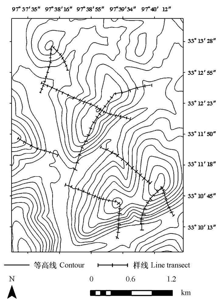
图1 石渠县云波沟研究区域样线分布
Fig. 1 Line transects distribution in the study area in Yunbo Gou, Shiqu County, Sichuan Province
| NDVI分级 NDVI groups | NDVI均值 Mean value of each NDVI group (± SD) | 像元数 Number of pixels | 各级像元所占比率 Percentage of pixels in each group (%) |
|---|---|---|---|
| 0.1-0.2 | 0.164 ± 0.029 | 3,166 | 2.8 |
| 0.2-0.3 | 0.266 ± 0.025 | 19,978 | 17.4 |
| 0.3-0.4 | 0.353 ± 0.029 | 47,482 | 41.4 |
| 0.4-0.5 | 0.440 ± 0.024 | 43,305 | 37.8 |
| 0.5-0.6 | 0.510 ± 0.079 | 639 | 0.6 |
| 总数 Total | 0.366 ± 0.076 | 114,570 | 100 |
表1 石渠县云波沟研究地区NDVI总体分布
Table 1 The distribution of NDVI values in the study area in Yunbo Gou, Shiqu County.
| NDVI分级 NDVI groups | NDVI均值 Mean value of each NDVI group (± SD) | 像元数 Number of pixels | 各级像元所占比率 Percentage of pixels in each group (%) |
|---|---|---|---|
| 0.1-0.2 | 0.164 ± 0.029 | 3,166 | 2.8 |
| 0.2-0.3 | 0.266 ± 0.025 | 19,978 | 17.4 |
| 0.3-0.4 | 0.353 ± 0.029 | 47,482 | 41.4 |
| 0.4-0.5 | 0.440 ± 0.024 | 43,305 | 37.8 |
| 0.5-0.6 | 0.510 ± 0.079 | 639 | 0.6 |
| 总数 Total | 0.366 ± 0.076 | 114,570 | 100 |
| NDVI分级 NDVI group | 取样单元数 Number of sampling units | 理论比例 Theoretical proportion (Pt)a | 洞穴数观测值 Observed burrow number | 洞穴数期望值 Expected burrow number b | 洞穴数观测值比例 Proportion of observed burrow number in each group (Po)c | 洞穴数观测值比例Bonferroni95%置信区间 95% Bonferroni intervals of Po | 显著性 Significance |
|---|---|---|---|---|---|---|---|
| 0.1-0.2 | 43 | 0.018 | 180 | 293 | 0.011 | 0.009 ≤ Po≤ 0.012 | – |
| 0.2-0.3 | 324 | 0.134 | 1,672 | 2,207 | 0.101 | 0.095 ≤ Po≤ 0.107 | – |
| 0.3-0.4 | 1,082 | 0.446 | 7,246 | 7,372 | 0.439 | 0.429 ≤ Po≤ 0.449 | 0 |
| 0.4-0.5 | 962 | 0.397 | 7,273 | 6,554 | 0.441 | 0.441 ≤ Po≤ 0.449 | + |
| 0.5-0.6 | 12 | 0.005 | 137 | 82 | 0.008 | 0.006 ≤ Po≤ 0.010 | + |
| 总数 Total | 2,423 | 16,508 |
表2 高原鼠兔有效洞穴数量在各级NDVI组中分布的Bonferroni z检验
Table 2 Bonferroni z test results of the distribution of active plateau pika burrow numbers in each NDVI group
| NDVI分级 NDVI group | 取样单元数 Number of sampling units | 理论比例 Theoretical proportion (Pt)a | 洞穴数观测值 Observed burrow number | 洞穴数期望值 Expected burrow number b | 洞穴数观测值比例 Proportion of observed burrow number in each group (Po)c | 洞穴数观测值比例Bonferroni95%置信区间 95% Bonferroni intervals of Po | 显著性 Significance |
|---|---|---|---|---|---|---|---|
| 0.1-0.2 | 43 | 0.018 | 180 | 293 | 0.011 | 0.009 ≤ Po≤ 0.012 | – |
| 0.2-0.3 | 324 | 0.134 | 1,672 | 2,207 | 0.101 | 0.095 ≤ Po≤ 0.107 | – |
| 0.3-0.4 | 1,082 | 0.446 | 7,246 | 7,372 | 0.439 | 0.429 ≤ Po≤ 0.449 | 0 |
| 0.4-0.5 | 962 | 0.397 | 7,273 | 6,554 | 0.441 | 0.441 ≤ Po≤ 0.449 | + |
| 0.5-0.6 | 12 | 0.005 | 137 | 82 | 0.008 | 0.006 ≤ Po≤ 0.010 | + |
| 总数 Total | 2,423 | 16,508 |
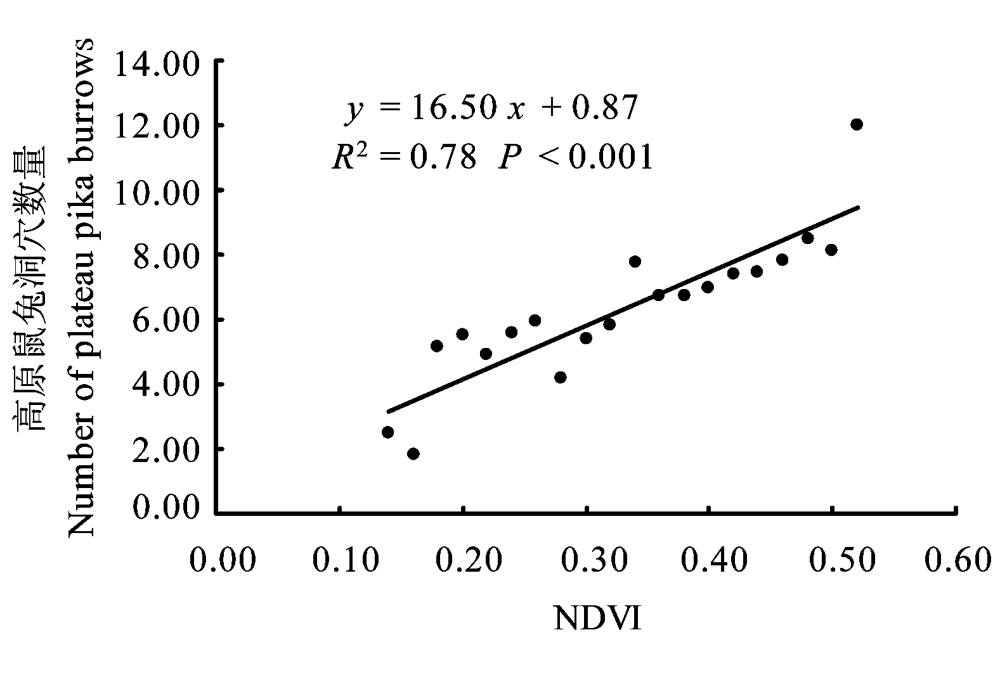
图2 NDVI组值与各组高原鼠兔洞穴数量均值的一元线性回归
Fig. 2 One-dimensional linear regression between NDVI and the average number of plateau pika burrows in each NDVI group
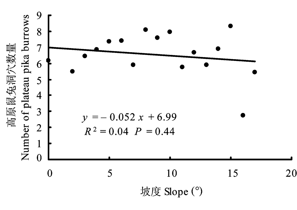
图3 坡度与各组高原鼠兔洞穴数量均值的一元线性回归
Fig. 3 One-dimensional linear regression between slope and the average number of plateau pika burrows in each slope group
| [1] | Arthur AD, Pech RP, Davey C, Jiebu, Zhang YM, Lin H (2008) Livestock grazing, plateau pikas and the conservation of avian biodiversity on the Tibetan Plateau. Biological Conservation, 141,1972-1981. |
| [2] | Bian JH (边疆晖), Jing ZC (景增春), Fan NC (樊乃昌), Zhou WY (周文扬) (1999) Influence of cover on habitat utilization of plateau pika (Ochotona curzoniae). Acta Theriologica Sinica (兽类学报), 19,212-220. (in Chinese with English abstract) |
| [3] | Collaborating Group for Vegetation of Sichuan (四川植被协作组) (1980) Vegetation of Sichuan Province (四川植被), pp.208-235. Sichuan People’s Publishing House, Chengdu. (in Chinese) |
| [4] | Giraudoux P, Pradier B, Delattre P, Deblay S, Salvi D, Defaut R (1995) Estimation of water vole abundance by using surface indices. Acta Theriologica, 40,77-96. |
| [5] | Giraudoux P, Quere JP, Delattre P, Bao GS, Wang XM, Shi DZ, Vuitton D, Craig PS (1998) Distribution of small mammals along a deforestation gradient in southern Gansu, central China. Acta Theriologica, 43,349-362. |
| [6] | Huete A, Didan K, Miura T, Rodriguez EP, Gao X, Ferreira LG (2002) Overview of the radiometric and biophysical performance of the MODIS vegetation indices. Remote Sensing of Environment, 83,195-213. |
| [7] | Ito TY, Miura N, Lhagvasuren B, Enkhbileg D, Takatsuki S, Tsunekawa A, Jiang Z (2006) Satellite tracking of Mongolian gazelles ( Procapra gutturosa) and habitat shifts in their seasonal ranges. Journal of Zoology, 269,291-298. |
| [8] | Jense JR (translated by Chen XL (陈晓玲), Gong W (龚威), Li PX (李平湘), Tian LQ (田礼乔)) (2007) Introductory Digital Image Processing: A Remote Sensing Perspective (遥感数字影像处理导论), 3rd edn., pp.299-300. China Machine Press, Beijing. (in Chinese) |
| [9] | Jiang ZG (蒋志刚), Xia WP (夏武平) (1987) The niches of yaks, Tibetan sheep and plateau pikas in the alpine meadow ecosystem. Acta Biologica Plateau Sinica (高原生物学集刊), 6,115-146. (in Chinese with English abstract) |
| [10] | Jing ZC (景增春), Wang QJ (王启基), Shi HL (史惠兰), Ma YS (马玉寿), Shi JJ (施建军) (2006) The poison effect experiment of Botulin model D for plateau pikas (Ochotona curzoniae). Pratacultural Science (草业科学), 23(3),89-91. (in Chinese with English abstract) |
| [11] | Komonen M, Komonen A, Otgonsuren A (2003) Daurian pikas ( Ochotona daurica) and grassland condition in eastern Mon- golia. Journal of Zoology, 259,281-288. |
| [12] | Li WJ (李文靖), Zhang YM (张堰铭) (2006) Impacts of plateau pikas on soil organic matter and moisture content in alpine meadow. Acta Theriologica Sinica (兽类学报), 26,331-337. (in Chinese with English abstract) |
| [13] | Liu JK (刘季科), Wang X (王溪), Liu W (刘伟), Nie HY (聂海燕) (1991) Effect of experimental grazing level of Tibetan sheep on rodent communities. In: Alpine Meadow Ecosystem Ⅲ (高寒草甸生态系统, 第3集) (eds Liu JK (刘季科), Wang ZW (王祖望)), pp.9-20. Science Press, Beijing. (in Chinese with English abstract) |
| [14] | Liu JK (刘季科), Wei SW (魏善武), Zhou L (周立), Sha Q (沙渠), Liu Y (刘阳) (1986) A study on the mathematical model for the dynamic of plants and plateau pika system. Acta Biologica Plateau Sinica (高原生物学集刊), 5,45-53. (in Chinese with English abstract) |
| [15] | Liu W (刘伟), Wang X (王溪), Zhou L (周立), Zhou HK (周华坤) (2003) Studies on destruction, prevention and control of plateau pikas in Kobresia pygmaea meadow. Acta Theriologica Sinica (兽类学报), 23,214-219. (in Chinese with English abstract) |
| [16] | Liu W (刘伟), Zhang Y (张毓), Wang X (王溪), Zhao JZ (赵建中), Xu QM (许庆民), Zhou L (周立) (2009) The relationship of the harvesting behavior of plateau pikas with the plant community. Acta Theriologica Sinica (兽类学报), 29,40-49. (in Chinese with English abstract) |
| [17] | Liu QX (刘群秀) (2009) Activity Rhythm, Home Range and Habitat Selection of the Tibetan Fox (藏狐活动规律、家域特征及生境特征的研究). PhD dissertation, School of Life Science, East China Normal University, Shanghai. (in Chinese with English summary). |
| [18] |
Lloret F, Lobo A, Estevan H, Maisongrande P, Vayreda J, Terradas J (2007) Woody plant richness and NDVI response to drought events in Catalonian (northeastern Spain) forests. Ecology, 88,2270-2279.
DOI URL PMID |
| [19] | Marston CG, Armitage RP, Danson FM, Giraudoux P, Ramirez A, Craig PS (2007) Spatio-temporal modelling of small ma- mmal distributions using MODIS NDVI time-series date. Authority Files for ISPRS. http://www.isprs.org/procee-dings/XXXVI/7-C50/P9_Marston_NDVI.pdf. |
| [20] | Neu CW, Byers CR, Peek JM (1974) A technique for analysis of utilization-availability data. The Journal of Wildlife Management, 38,541-545. |
| [21] | Pech RP, Jiebu, Arthur AD, Zhang YM, Lin H (2007) Population dynamics and responses to management of plateau pikas (Ochotona curzoniae). Journal of Applied Ecology, 44,615-624. |
| [22] | Qu JP (曲家鹏), Li KX (李克欣), Yang M (杨敏), Li WJ (李文靖), Zhang YM (张堰铭), Smith AT (2007) Seasonal dynamic pattern of spacial territory in social groups of plateau pikas (Ochotona curzoniae). Acta Theriologica Sinica (兽类学报), 27,215-220. (in Chinese with English abstract) |
| [23] | Quéré JP, Raoul F, Giraudoux P, Delattre P (2000) An index method of estimating relative population densities of the common vole ( Microtus arvalis) at landscape scale. Revue d'écologie, 55,25-32. |
| [24] | Raoul F, Quere JP, Rieffel D, Bernard N, Takahashi K, Scheifler R, Ito A, Wang Q, Qiu JM, Yang W, Craig PS, Giraudoux P (2006) Distribution of small mammals in a pastoral landscape of the Tibetan Plateau (western Sichuan, China) and relationship with grazing practices. Mammalia, 70,214-225. |
| [25] | Retzer V, Reudenbach C (2005) Modelling the carrying capacity and coexistence of pika and livestock in the mountain steppe of the South Gobi, Mongolia. Ecological Modelling, 189,89-104. |
| [26] | Roach WJ, Huntly N, Inouye R (2001) Talus fragmentation mitigates the effects of pikas,Ochotona princeps, on high alpine meadows. Oikos, 92,315-324. |
| [27] | Schaller GB (1998) Wildlife of the Tibetan Steppe, pp.179-185. The University of Chicago Press, Chicago. |
| [28] | Smith AT, Foggin JM (1999) The plateau pika ( Ochotona curzoniae) is a keystone species for biodiversity on the Tibetan Plateau. Animal Conservation, 2,235-240. |
| [29] |
Vaniscotte A, Pleydell DRJ, Raoul F, Quere JP, Qiu JM, Wang Q, Li TY, Bernard N, Coeurdassier M, Delattre P, Takahashi K, Weidmann JC, Giraudoux P (2009) Modelling and spatial discrimination of small mammal assemblages: an example from western Sichuan (China). Ecological Modelling, 220,1218-1231.
DOI URL PMID |
| [30] | Wang MJ (王梦军), Zhong WQ (钟文勤), Wan XR (宛新荣), Wang GH (王广和) (1998) Habitat selection during dispersion of Daurian pika (Ochotona daurica). Acta Zoologica Sinica (动物学报), 44,398-405. (in Chinese with English abstract) |
| [31] | Wang ZH, Wang XM, Lu QB (2007) Selection of land cover by the Tibetan fox Vulpes ferrilata on the eastern Tibetan Plateau, western Sichuan Province, China. Acta Theriologica, 52,215-223. |
| [32] | Wang ZH (王正寰), Wang XM (王小明) (2006) Ecological characteristics of Tibetan fox dens in Shiqu County, Sichuan Province, China. Zoological Research (动物学研究), 27,18-22. (in Chinese with English abstract) |
| [33] | Wang ZW (王祖望), Liu JK (刘季科), Su JP (苏建平), Liu Y (刘阳), Dou FM (窦丰满) (1987) Energy dynamics of small mammals in an alpine meadow ecosystem Ⅱ. An estimation of energy flow through the population of plateau pika, Ochotona curzoniae. Acta Theriologica Sinica (兽类学报), 7,189-202. (in Chinese with English abstract) |
| [34] | Wei WH (魏万红), Cao YF (曹伊凡), Zhang YM (张堰铭), Yin BF (殷宝法), Wang JL (王金龙) (2004) Influence of the predation risk on the behavior of the plateau pika. Acta Zoologica Sinica (动物学报), 50,319-325. (in Chinese with English abstract) |
| [35] | Wei YX (卫亚星), Wang LW (王莉雯), Liu C (刘闯) (2008) Grassland classification based on MODIS NDVI time series data in Qinghai Province. Resources Science (资源科学), 30,688-693. (in Chinese with English abstract) |
| [36] | Wiegand T, Naves J, Garbulsky MF, Fernandez N (2008) Animal habitat quality and ecosystem functioning: exploring seasonal patterns using NDVI. Ecological Monographs, 78,87-103. |
| [37] | Yang ZY (杨振宇), Jiang XL (江小蕾) (2002) The harm of plateau pika on grassland vegetation and its control threshold value. Pratacultural Science (草业科学), 19(4),63-65. (in Chinese with English abstract) |
| [38] | Yang JP (杨建平), Ding YJ (丁永建), Chen RS (陈仁升) (2005) NDVI reflection of alpine vegetation changes in the source regions of the Yangtze and Yellow rivers. Acta Geographica Sinica (地理学报), 60,467-478. (in Chinese with English abstract) |
| [39] | Zong H (宗浩), Fan NC (樊乃昌), Yu FX (于福溪), Zhu JC (朱嘉诚) (1991) The research on the population spatial patterns of the plateau zokor ( Myospalax baileyi) and the plateau pika ( Ochotona curzoniae) in the alpine meadow ecosystem. Acta Ecologica Sinica (生态学报), 11,125-129. (in Chinese with English abstract) |
| [1] | 罗正明, 刘晋仙, 张变华, 周妍英, 郝爱华, 杨凯, 柴宝峰. 不同退化阶段亚高山草甸土壤原生生物群落多样性特征及驱动因素[J]. 生物多样性, 2023, 31(8): 23136-. |
| [2] | 鲍虞园, 李银康, 林吴颖, 周志琴, 肖晓波, 颉晓勇. 中国南海北部近海鲎资源调查及北部湾潮间带中华鲎幼鲎潜在栖息地评估[J]. 生物多样性, 2023, 31(5): 22407-. |
| [3] | 张琼悦, 邓卓迪, 胡学斌, 丁志锋, 肖荣波, 修晨, 吴政浩, 汪光, 韩东晖, 张语克, 梁健超, 胡慧建. 粤港澳大湾区城市化进程对区域内鸟类分布及栖息地连通性的影响[J]. 生物多样性, 2023, 31(3): 22161-. |
| [4] | 王怡涵, 赵倩倩, 刁奕欣, 顾伯健, 翁悦, 张卓锦, 陈泳滨, 王放. 基于红外相机调查上海市区小灵猫的活动节律、栖息地利用及其对人类活动的响应[J]. 生物多样性, 2023, 31(2): 22294-. |
| [5] | 李婷婷, 朱锡红, 吴光年, 宋虓, 徐爱春. 镇海棘螈产卵场微生境选择[J]. 生物多样性, 2023, 31(1): 22293-. |
| [6] | 王双贵, 郭志宏, 顾伯健, 李天醍, 苏玉兵, 马伯丞, 管宏信, 黄巧雯, 王放, 张卓锦. 六盘山华北豹的栖息地利用及保护建议[J]. 生物多样性, 2022, 30(9): 22342-. |
| [7] | 马子驭, 何再新, 王一晴, 宋大昭, 夏凡, 崔士明, 苏红信, 邓建林, 李平, 李晟. 中国云豹种群分布现状与关键栖息地信息更新[J]. 生物多样性, 2022, 30(9): 22349-. |
| [8] | 符龙飞, 韦毅刚. 中国喀斯特洞穴维管植物多样性[J]. 生物多样性, 2022, 30(7): 21537-. |
| [9] | 秦乐, 朱彦鹏, 任月恒, 李博炎, 付梦娣, 李俊生. 青藏高原国家级自然保护区管理能力差异及其对保护成效的影响[J]. 生物多样性, 2022, 30(11): 22419-. |
| [10] | 阿卜杜赛麦提·买尔迪亚力, 王云, 陶双成, 孔亚平, 王昊, 吕植. 我国道路对野生动物影响研究的现状与挑战[J]. 生物多样性, 2022, 30(11): 22209-. |
| [11] | 滕继荣, 刘兴明, 何礼文, 王钧亮, 黄建, 冯杰, 王放, 翁悦. 甘肃白水江国家级自然保护区林缘社区饲养犬只对大熊猫时空节律的影响[J]. 生物多样性, 2022, 30(1): 21204-. |
| [12] | 王博驰, 裴雯, 杨巨才, 色拥军, 李雪竹, 娜尔力玛, 杨海蓉. 甘肃盐池湾黑颈鹤筑巢栖息地偏好及人为干扰的影响[J]. 生物多样性, 2022, 30(1): 21241-. |
| [13] | 徐承香, 赵璐, 杜维锋, 张思强, 吴永英, 周非. 贵州荔波玉屏洞穴陆生动物食物来源及营养级[J]. 生物多样性, 2021, 29(8): 1108-1119. |
| [14] | 武鹏峰, 崔淑艳, Abid Ali, 郑国. 蜘蛛飞航研究进展[J]. 生物多样性, 2021, 29(4): 517-530. |
| [15] | 黄越, 顾燚芸, 阳文锐, 闻丞. 如何在北京充分实现受胁鸟类栖息地保护?[J]. 生物多样性, 2021, 29(3): 340-350. |
| 阅读次数 | ||||||
|
全文 |
|
|||||
|
摘要 |
|
|||||
备案号:京ICP备16067583号-7
Copyright © 2022 版权所有 《生物多样性》编辑部
地址: 北京香山南辛村20号, 邮编:100093
电话: 010-62836137, 62836665 E-mail: biodiversity@ibcas.ac.cn